
The Faroe Islands are an archipelago between the Norwegian Sea and the North Atlantic, about halfway between Norway and Iceland, 320 kilometers (200 miles) north-northwest of Scotland. The islands are an autonomous country within the Kingdom of Denmark. Their area is about 1,400 square kilometers (541 square miles) with a population of 50,322 in October 2017.
The Faroes' terrain is rugged, and the islands have a subpolar oceanic climate: windy, wet, cloudy, and cool. Despite this island group's northerly latitude, temperatures average above freezing throughout the year because of the Gulf Stream.

Google Map Of the Faroe Islands
Between 1035 and 1814, the Faroes were part of the Hereditary Kingdom of Norway. In 1814, the Treaty of Kiel granted Denmark control over the islands, along with two other Norwegian island possessions: Greenland and Iceland.
The Faroe Islands have been a self-governing country within the Kingdom of Denmark since 1948. The Faroese have control of most domestic matters. Areas that remain the responsibility of Denmark include military defense, policing and the justice department, currency, and foreign affairs.

Faroe Islands Sheep
However, as they are not part of the same customs area as Denmark, the Faroe Islands have an independent trade policy and can establish trade agreements with other states. The islands also have representation in the Nordic Council as members of the Danish delegation. The Faroe Islands also have their own national teams competing in certain sports.

Faroese Fishing Boats
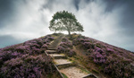
Day One: Elduvik
Elduvík is located in the Funningsfjørður-inlet on Eysturoy's northeast side. The village which has a population of 23 is split into two parts by a small river. The church in Elduvík dates from 1952. Visible from Elduvík is the nearby island of Kalsoy. This was our base for two nights to explore the best landscape spots within 30 minutes drive. Our accommodation was in a grass-roofed house and built over 200 hundred years ago. With recent renovations of the property, it was very comfortable as seen in the pictures above.
Funningsfjørður is a village located at the end of a fjord of the same name. It was founded in 1812 and has since 2005 been part of the municipality of Runavík. From Elduvik it's a quick 15-minute drive and on the way to other key locations 30 minutes away.

Elduvik Cottage
Eiði is a village located on the north-west tip of Eysturoy, Faroe Islands. Its name means isthmus in the Faroese language. The town has a population of 669 inhabitants. Eiði was settled by Vikings in the 9th century AD. Just outside the village, you can capture some great vantage points for a spectacular sunset. The drive into the valley is equally as spellbinding.

Sunrise from Eidi
Gjógv is a village located on the northeast tip of the island of Eysturoy, in the Faroe Islands and 63 km north by road from the capital of Tórshavn. If you are driving to Eidi you might as well have a quick look as it's only a 15-minute detour on the way back to Funingur.

Gjogv Village
The drive into Eiði before sunset was surreal with the clouds hanging low over Eiði lake. The sheep were extremely friendly and posed nicely for a sunset shot.

Eiði Lake
Day Two: Viðareiði
Viðareiði is the northernmost settlement in the Faroe Islands and lies on the Island of Viðoy, which belongs to the Norðoyar Region. From Elduvik it takes about an hour driving through various underground tunnels that connect the islands. Viðareidis church is a stone church in Viðareiði built in 1892. It is beautifully situated, overlooking the sea and towards Enniberg and Kunoyarnakkur. Despite not being able to see these two points because of cloud and fog cover the atmosphere of the area was eerie and calming. Calming because of the low tide and eerie because of the cloud and fog. The green grass is lush and has deep tones of dark olive.

Viðareidis church
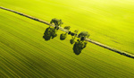
There are more sheep (70K) than people living on the islands. Since most islands are treeless and are elongated in shape, most roads run along the perimeter. You are never more than 5km to the nearest shoreline. Its main industry is Salmon Fish Farms which can be seen dotted everywhere. Lamb is also the main industry and all other food products are flown in daily from Denmark. At the local supermarket, you find lots of fresh fruit and vegetables. Another fun fact about the sheep is their clever use as a tourist campaign to join forces with Google maps. Attaching cameras to their backs we are now able to get some unique street and mountain views.

Hvannasund Village
On the way back to Elduvik we passed Hvannasund a village located on the west coast of the island of Viðoy. It faces Norðdepil on Borðoy. The villages are connected to each other by a causeway where the image above was taken.
There are no traffic lights in the tunnels so when crossing over islands you might have one lane. Within the tunnels, there are spots you can pull into while a car drives past. The capital of Torshavn has three traffic lights as this is where most people live (21K).

The Long And Winding Roads of The Faroe Islands
Day Three: Torshavn
Tórshavn, on Streymoy Island, is the capital city of the Faroe Islands. It's known for its old town, Tinganes, crammed with wooden turf-roofed houses on a small peninsula. When the roof meets the ground level sheep are used to mow the lawn. Staying in one of these houses is a great experience when visiting the Faroes.

Old Town in Torshavn
On the 1st of June, we happened to be in town for Cultural Night. All shops open till 11 pm and many food stalls line the streets in festive ambiance of community. Music is a big part of Faroese culture with many bands and indie artists performing at various venues. We stumbled upon a local talent called Jasmine at the Sirkus Bar. Our accommodation owned by a famous fashion designer called Gudrun & Gudrun was stylish and comfortable with a relaxing view of a small port in front of the cottage. Fog seemed to be engulfing the town during our stay as we heard fog horns blowing for most of the early morning.

Gudrun House in Toshavn
The Faroe Islands may not be an independent country, but it still has one of the oldest Parliaments in the world. Tinganes, where parliament first met in the 9th century, is probably one of the oldest parliamentary meeting places in the world that is still in use. It is also a picturesque part of the capital city, Torshavn.
Sheep are clearly a national staple, in fact, the islands’ name comes from the Viking word for sheep, but salmon is equally as important, and delicious. The local company Bakkafrost is the eight largest salmon farming company in the world.

Torshavn Port in thick fog.
Day Four: Sandavagur
Sandavágur is a city on the south coast of the Faroese island of Vágar, and has been voted the most well-kept village in the Faroes twice. The highlight of the area is photographing what is close by. If you are looking for cascading waterfalls flowing into the ocean from cliff tops, then Gasadalur is only a 30-minute drive away. On the way there you will see the arch-shaped mammoth rock and spike tops on the island next to it. Drangarnir is the collective name for two sea stacks between the islet Tindhólmur and the island Vágar in the Faroe Islands. The individual names of the sea stacks are Stóri Drangur and Lítli Drangur.

Drangarnir
If you wish to get a closer look at Drangarnir an eight-hour return walk is needed to get to the closest cliffs. The village of Bøur is a village in the Sørvágur Municipality of the Faroe Islands, four km west of Sørvágur, with a population of 75 is where you can get this view. The ferry pictured below is coming back from the island of Mykines where if you are lucky you can see puffin birds.

Drangarnir & Tindholmur
From Bøur to Gandasalur is a 10-minute drive. They have recently marked the cliff top walk to the cascading Mulafossur Waterfall to avoid accidents. If some torrential rain has come and high tide is hitting the coastline you can get some atmospheric shots. We, unfortunately, had a beautiful clear blue sky day which is very rare.

Mulafossur Waterfall

Mulafossur Waterfall
Reality VS Expectation: Unfortunately, the fourth day we attempted the two-hour return climb to Trælanípan to view Sorvagsvatn Lake we had zero visibility with heavy fog. Despite waiting for an hour at the cliff top view this is all we saw. Have a look at this spot we missed out on from Mads Petersen videos.

Trælanípan
Day Five: Witches Finger
In the village of Sandavagur, you can take the short walk along the cliff face. On our final day on the way to the airport, we crossed our fingers to hope for a break in the fog that had been covering the witches finger for 24 hours. Low and behold for a brief moment we saw her for this quick shot. Have you been to the Faroe Islands? What other spots can you recommend? I will be going back soon on my private workshops and will be staying at least 7 days.

Witches Finger
If you have been to the Faroe Islands and have other suggestions or locations not mentioned please add them in the comments below. I can't wait to go back on my regular photo tour.


![There Is Nothing Like Photographing a Sunrise [Part 3]](https://cdn.fstoppers.com/styles/small-16-9/s3/lead/2017/03/cape_cod_sunrise_dock_photo.jpg)
Really nice photos and very interesting write-up. Thanks a lot!
Thanks
And the band Tyr!
Awesome photos.
There's also a giant whale hunt that happens there- grindadráp
Thanks
Awesome shots. My wife is from the Faroe Islands, so I get to shoot there a couple of times every year.
I would add the Island of Mykines to the far West to the list. It’s puffin heaven. You can only get there by boat or Helicopter. But flying helicopter is pretty cheap on the Faroe Islands. A oneway trip is about 30 USD.
Also make sure you visit the actual village of Funning and thier old Church.
Make sure you go in spring or summer, because they have massive storms an hurricanes in late Fall and winter. Afterall the Islands are in the middle of the Atlantic ocean :)
Thanks
Would you tell us more about the Faroe culture? Do they resemble Danish or have other special lifestyle features?
https://youtu.be/5qinWJqgGMw
Alfonso it is very good and detailed presentation with amazing photos s despite the foggy weather. Would you tell more about locals? What are they doing for living? What's the culture like? Do they see lots of tourists?
Thanks
Faroes are proud of their national football team! How is everyday life up there?
Great photos ruined by excessive use of filters...
Thanks
I was there last september - it's like a big big fairy tale everywhere. The people on the islands are unbeliveable friendly and you can talk to them about nearly everything - maybe not their traditions, but if you do it respectful it works great.
The beer is quite expensive, but you need to try it! If you want to get there, get weather-sealed gear and clothes - really, the weather changes 4-7 times a day. You can sit at breakfast - fog everywhere - then rain and clear sunshine at 12 o'clock. What else - oh you need to go there when a football game is running in Torshavn and then go into a pub and have the greatest party ever going one - even then the home team loses. So: really lovely people, nice beer, an unbeliveable landscape (watch where you step and dont walk on cliffs without a guide!), crazy weather.
Some images: https://500px.com/philgabriel/galleries/faroe-islands-visit-faroe-islands
PS: Be respectful with their traditions, with the people and the environment!
Great advice
Great guide & photos. If you have the time I would also suggest people to take a guided tour (around 70 euros) to a short 40 minute hike from Trøllanes out to the picturesque lighthouse at the edge of the island of Kalsoy. The great thing about the unique Faroe Islands is that they have excellent infrastructure with great roads, tunnels and sub-sea tunnels that make it possible to see so much within a short drive distance. But if people have time for it I strongly suggest people to take the time to take the ferry to the island of Suðuroy. It is spectacular, plus even less travelled by tourists since it takes more time to visit that island compared to the islands up north that are better connected with bridges, tunnels... I would also recommend you to check out www.visitfaroeislands.com (offical tourist site of the islands) for further info & inspiration
Thanks a million! Any great Landscape Photography Locations in Suðuroy? Day trip or over night stay?
I have been there, this is amazing place indeed. Awesome shots btw <3
kevin
https://publixpassport.us