
For the last 10 years I have been regularly visiting this remote and pristine island state. Tasmania is about a 1.5 hour flight from Sydney to the city of Launceston. The diverse choice of landscapes and close proximity by car make this a unique and accessible environment still largely untouched. Around 40 percent of Tasmania is protected National Parks and Reserves. If you are looking to get off the grid and discover a magical wilderness, this place is filled with adventure and convict history. Here are some of my favorite spots to photograph in spring or autumn. I have also added a few other locations as side trips that are also worth a look.

Tasmania road map of the five best photo locations.
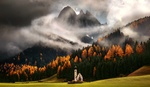
1. Cradle Mountain National Park
A two-hour drive from Launceston Airport will take you to Dove Lake and a spectacular view of Cradle Mountain. Like most mountains, it can be difficult to predict the weather. Tasmania National Parks have various walks that can take two hours or six days, depending on your level of fitness. You can expect to see a few wombats, wallabies, and Tasmanian devils (in captivity). Unfortunately, there is a lot of road kill so best not to drive through these parks in the dark. The local wildlife tend to freeze and stop in the middle of the road when blinded by car lights.The weather can turn on you at any moment so best to come well prepared with warm clothing and weatherproof gear.
The area is covered in a variety of alpine and sub-alpine vegetation. Alpine coral fern and button grass dominate the alpine wet sedge lands near the mountain summit. Tasmanian snow gums can be found at slightly lower elevations alongside pencil pine and waratah. Within the valleys surrounding the mountain, species such as myrtle beech and pandani (unique to Tasmania) form thick temperate forest with dense, mossy undergrowth. The geology of the mountain is Jurassic dolerite.

Dove Lake
2. Bicheno
Bicheno is located 176 kilometers (109 miles) southeast of Launceston. It used to be a whaling town in the early 1800s. Today it is a charming seaside resort town and the local fishing industry's catch includes substantial quantities of abalone, crayfish, scallops, and trevally. In the photo below you can see the famous Rocking Rock (80 ton piece of granite). There are a number of interesting access points onto the rocks which have a distinctive red color as a result of deposits of red lichen; All perfect for a slow shutter and a 10-stop filter if you choose to shoot in the middle of the day. There is also a blowhole nearby that shoots out water up to 10 feet high. Many of these rocks resemble sea creatures such as whales and sea lions. At night along the coastal beaches you might spot some fairy penguins coming in after sunset.

Red/orange lichen on Bicheno's boulders
3. Sleepy Bay, Freycinet National Park
Just a 30 minute drive from Bicheno is Coles Bay. Famous features of the park include its red and pink granite formations and a series of jagged granite peaks in a line called "The Hazards." If you are lucky you might spot some Bennet's wallabies, brushtail possums, eastern quoll, echidnas, and wombats. Out in the ocean you might spot some humpback whales and bottlenose dolphins.

Freycinet Lodge Jetty sunset
Up in the sky or perched on trees are white-bellied eagle, black-browed albatross, brown falcon, and fairy wren to name a few. Banksia and Eucalyptus Gum trees dominate the area. There are various walks but the most common would have to be Wineglass Bay which has been voted in as one of the top 10 beaches in Australia.

Sleepy Bay sunrise
4. Tessellated Pavement
The Tessellated Pavement State Reserve is on the Tasman Peninsula near Eaglehawk Neck. The region is popular with a short drive from here to Port Arthur Convict Settlement. Also known for a massacre in 1996 of 35 who were killed by a mad gunman. It is the deadliest mass shooting in Australia's history. Since then, our gun laws restrict the private ownership of high-capacity semi automatic rifles and shotguns as well as introducing uniform firearms licensing. The area has a melancholic feel. The best time of year to photograph the chess board like pavement is in May when moss on the rocks is more abundant.

Tessellated Pavement
5. Horseshoe Falls
Only an hour and a half drive out of Hobart is Mt. Field National Park where you will find Russell And Horseshoe Falls. Nestled in a moss forest are towering swamp gums, the tallest flowering plant on earth, and species typical of wet forests and cool temperate rainforests, such as dogwood, musk, and myrtle. Towards the falls, the track is framed by stunning tall tree ferns. The falls themselves are impossibly picturesque.

Mt. Field National Park is where Russell and Horseshoe Falls are located.
Other Points of Interest
Liffey is an area where many farms have abandoned houses and sheds. Rumored to have paranormal activity, this wool shed stands on its last legs. Liffey is also known for its cascading waterfalls.

Liffey abandoned woolshed
Derwent River Poplars in May is when autumn and all its colors come to life in the Derwent Valley only an hours drive from Hobart.

Derwent Valley River poplar trees in autumn (May).
Arthur's Lake is located only an hour and 15 minute drive from Launceston up in the highland lakes. The area is also known as the drowned forest because of the trees that were flooded for Hydro Tasmania. The lake is filled with trout and also makes for the perfect spot for some eerie shots.

Angler's paradise
Does Tasmania remind you of any other place in the world?


Thanks for your nice article and the photos. They are really wonderful.
When I found the article I was really excited, because I spent approx 1 year in Tasmania.
Please do not misunderstand. I love your photos a lot, but from the title I expected it goes more deep into the great beautiful wilderness of Tasmania and not just these common places.
But I look forward to see more of your work. Thanks.
The Tarkine and South West areas I have not yet explored. Have you been there? Any suggestions?
South West NP is great. Specially if you do the hike. Wonderful coastline and experiences. From my point of view, the Arthur Range is great as well, but hiking there is a bit tough.
Have you been to Bruny Island. It offers nice spots as well.
My photos are not so exciting likes yours, but maybe the give you some inspiration for your next visit .. http://www.kreitlein.de/reiseblog/photo-gallery/countries-%e5%9b%bd/aust...
I created long time a go this little overview of spots in Tasmania. The photos are in some case poor, but the idea was just to introduce Tassi ..
http://www.kreitlein.de/tasmanien/
Thanks for sharing
Thanks and I hope you'll have lot's of nice time in Tasmania. Like I told, I look forward to enjoy more of your photo.
I agree with Andre, the places you're talking about are beautiful but they are the hotspots of Tasmania, not really wilderness. Somewhere like Dove Lake is starting to look as busy as an American National Park. The North West, including the Tarkine, is really wild (and rainy). For hikers, Frenchmans cap, the Arthur ranges, Federation peak, the South West coast, Walls of Jerusalem, Mount Anne, Franklin Gordon rivers, those are the wild spots. It is hard to access sometimes. You need off track skills, to walk in deep mud, under constant rain, to do some bushwacking, it's hard on the mind. The East coast is "easier" with great places like the capes on the Tasman peninsula, or the real Bay of Fires at Mount Williams National Park. It's one of my favorite places on Earth.
Nice article and photos. Just one thing: they are "Fairy Penguins" not "Ferry Penguins" :-)
Updated, thanks!
Thank you for this. I visited Tasmania about a year ago and this would have been helpful, Tasmania seems like a difficult place to research. I managed to find some of these spot but definitely not all, mostly due to time.
The amount of road kill in Tasmania was shocking. I think you may understate this part. The first wallaby I ever saw was roadkill, as was the 20th.
On a different note, I took the Spirit of Tasmania ferry from Melbourne to Devonport, and it was a great trip. I took my rental car and slept on the ferry. It was nice.
Tasmania is such a great place. I appreciate the reminder that I need to go back.
Great little overview of Tassie! I live in Hobart and am constantly impressed with the variety and sheer beauty this island has to offer for landscape shooters.
If you are into doing some hikes to great locations you could add the following to the above itinerary.
Picnic Rocks/Eddystone point lighthouse: North of Bicheno with some amazing rock formations and a lighthouse!
Mt Amos/Mt Freycinet: Mt Amos is a day hike and gives you a great view of wineglass bay. Mt Freycinet is the highest point on the peninsular and can be gained with 2-3 days hiking.
Cape Hauy/Cape Raoul: A bit south of Tessellated pavement, day hikes.
Tarn Shelf: Mt Field NP, 1/2 drive up from horseshoe falls. Alpine hiking, amazing in Autumn when the fagus is on display. (Bonus points if you drive over to Gordon Dam/Lake Pedder
There is plenty more but if you are short on time/money it's a proud little trip :)
Wow thanks for your kind comments and amazing suggestions. Feel free to follow and suggest more through my instagram posts. @alfonsothephotographer
Which is the best camera to start photography
https://mycoles.org