
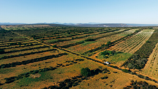
I was recently commissioned to photograph fields of Rooibos Tea (a healthy tea with no caffeine and great antioxidants found in South Africa) so the farmer could document his potential yield. He also wanted details, as in what side of the tea field to start planting so he could plan the sowing schedule for the next five years. The idea is to not sow on the same soil, so new rows of tea plants need to be formed in five years. Tea likes fresh, new soil.
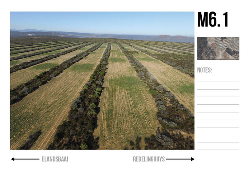
Tea fields generally look the same. So, in this case, it wasn’t only the photography that would answer the farmer's request. I needed to show which photo it was, and where it was on the map, so the farmer could identify the specific "camp."
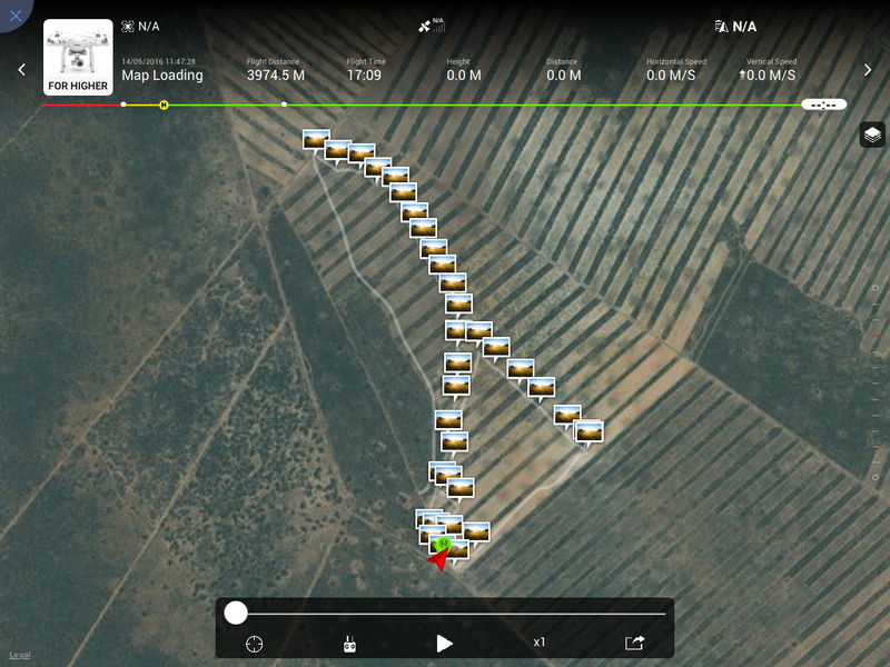
I therefore needed to use the drone’s GPS logs, as I myself was not able to remember which was which, (there where 80 camps). And I needed to show it in the best way possible, communicating the information so the farmer could identify the specific land and see the information available when looking at the photo.
The farmer had had aerial photographers before, but they delivered photos only, which would give him a broad idea of what the farm was doing, but it wasn’t something he could use to strategize or plan ahead. Therefore, I had to bring my design and layout skill-set or source it out to someone who could do it. I also had to use the technology the drone has to communicate what the farmer is looking at. This was a case where the farmer didn't really know what he could get, so I needed to show him.
To go ahead with the shoot, I needed to do some planning and do some research.
Equipment I was going to use on the day:
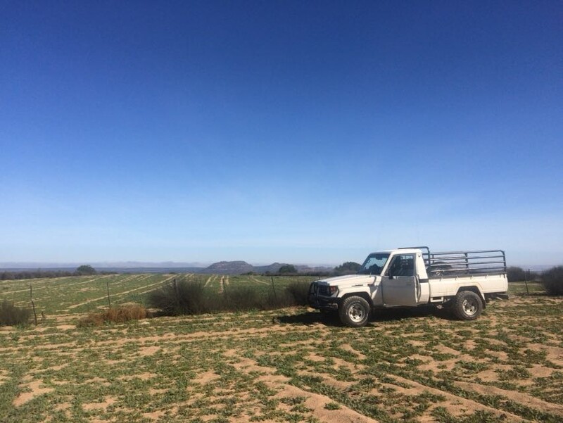
- DJI Phantom 3 Advanced
- 2 DJI Batteries (These were not enough, so I had to come back the next day.)
- iPhone for time-logging and GPS to see where I was
- iPad Mini as a monitor
- DJI Remote Controller Monitor Hood
The following questions needed to be answered:
- When was sunrise and sunset?
- Did I want the plantation to throw a shadow?
- How long does it take me to take photos of one plantation or camp? I needed to check how many times I needed to go for a charge and plan accordingly.
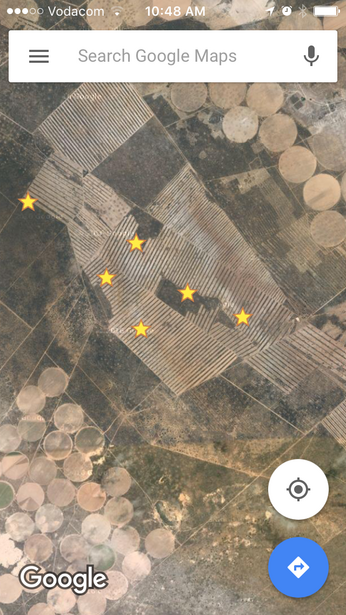
I went to the farm a day prior to the shoot to test-fly to see what it would look like. I could log each field on Google Maps on my iPhone and could name the markers to differentiate which one was which. This helped a lot with planning and execution.
With regards to the technology, I needed to use the GPS capabilities of the DJI Phantom 3 Advanced. The coordinates would let me know which field and row it was and also make the information communicable in the best way possible.
I have started the layout in Adobe InDesign, where the photo and map will be set up next to each other, with a small space for some note-taking. The opportunity I have now is to go show this document to other farmers. Most often, people don’t know what data capture is possible and how it can be turned into usable information for them to improve or analyze their farmlands and to estimate the yields they are looking at for the year.
The aim of this article is to let you know your drone can actually do some work. You can provide the farming community with information they never had or in the past would've had to hire a helicopter pilot and photographer for the day to gather. If you want to improve on what I've done, you can upgrade to the Inspire Pro and mount the Zenmuse XT Camera that gives you infrared so you can see the photosynthesis, how well the fields are hydrated, and if the intervals suit the soil and plantation.
Marketing This Service
Word of mouth is key in the agricultural industry. Farmers talk to each other a lot. If you can make good contact with one, they will be sure to recommend you to others. When I have completed this document, I'll have several printed to hand out to farmers. I will personally take the document to the farmer and go by the nearby farms to see if they require the same service.
This was a first for me, so I have learnt a lot:
- The flight logs are great, but they don't show you which photo was taken along the flight video. You can get the coordinates with the EXIF data of the images. You can then search these coordinates in Google Maps.
- I need more batteries for the Phantom. Two just don't cut it.
- I'm taking my laptop with me next time so I can download each flight into its own folder.
If you've done something similar and you have advice, please share in the comments!
Join the Fstoppers community for free
-
Post comments and join in the discussions
-
Browse the site ad-free
-
Share your work and get featured in the community
-
Compete in the photo contests for fun and prizes
7 Comments
Thanks for the agriculturally-related topic :)
Farmers and ranchers love drones and use them regularly to estimate yields, look for pests, and even locate lost or sick livestock.
Some companies are actually looking at using drones to delivery disease samples or blood samples of livestock for diagnostic purposes.
It's a pleasure man! Drones are making a big difference to everyday life. We're living in the future. I appreciate your feedback!
Yea, it might not be sexy, but I think there's some growth here for sure. I'm moving back to Maryland's Chesapeake Bay and have had this in my scan as something to look more into, so thanks for the affirmation. As a bonus, my zip code is just OUTSIDE the greater Washington D.C. are no-fly zone, so I hope to be one of the first to tap into this for corn, soybean and hay farmers in the area. Fly straight and fly right!
My full-time career is actually in agriculture and it's been great to combine my interests in photography with my career working with farmers. I have been working at the forefront of this technology and have the opportunity to work with some cutting edge companies who are using drones and imagery to count the number of plants in fields, evaluate the moisture levels of straw, look at the health of plants and even make fertilizer recommendations based off of imagery. There's definitely a lot of potential in this area for those who can make connections between imagery and helping a farmer be more successful.
Good stuff! So is there a budding forum where drone-ag guys swap stories? Or is this still DIY territory? I definitely want to get smarter especially before deciding on equipment and payload purchases.
A while ago I saw a video on Dutch TV about drones in farming. The video is also on youtube subtitled. The video is called "Firestarters | the Series, seizoen 2 #01 Old MacDonald had a drone (full)" link: https://www.youtube.com/watch?v=IlDbk9ae_xc
Great article, it certainly sparks some ideas in my mind.
One question I have for you. Would you be needing a commercial drone pilots license to be doing this in South Africa? Do you have a commercial license?
Thanks
Evan