
In today's digital age, there are numerous apps available that can significantly enhance your landscape photography experience. In this article, I want to take a look at the six apps that have proven invaluable for my own landscape photography.
The abundance of photography-related apps can make it challenging to choose the most suitable ones for your needs. From straightforward depth-of-field calculators to comprehensive planning tools, the options are vast.
Given the sheer abundance of available apps, it can be challenging to pinpoint the most valuable ones. Often, there's a strong emphasis on visually appealing designs that add little real value or information that's presented in a cluttered manner, making it hard to decipher.
For me, a good app should provide the necessary information without unnecessary clutter and visuals. The information should be easily accessible, easy to read, and the app must be reliable. While I prefer apps that are free of charge, I understand that developing these apps requires time and effort. That's why I don't mind paying for an app, as long as the price is reasonable and not tied to a monthly subscription.
I’ve tried a lot of apps in recent years and I’ve concluded there are only six that have proven to be invaluable for me as a landscape photographer. These six apps provide a wealth of information that is mostly focused on photography. This includes weather conditions of course. But also timetables for sun, moon, and tides. They can guide you to specific locations or help you discover the most interesting spots for your landscape photography.
Although there are plenty of other apps that appear to give even more information, often this is already covered in the six apps I use. Let’s take a look at the ones I can recommend to every landscape photographer out there.
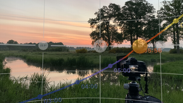
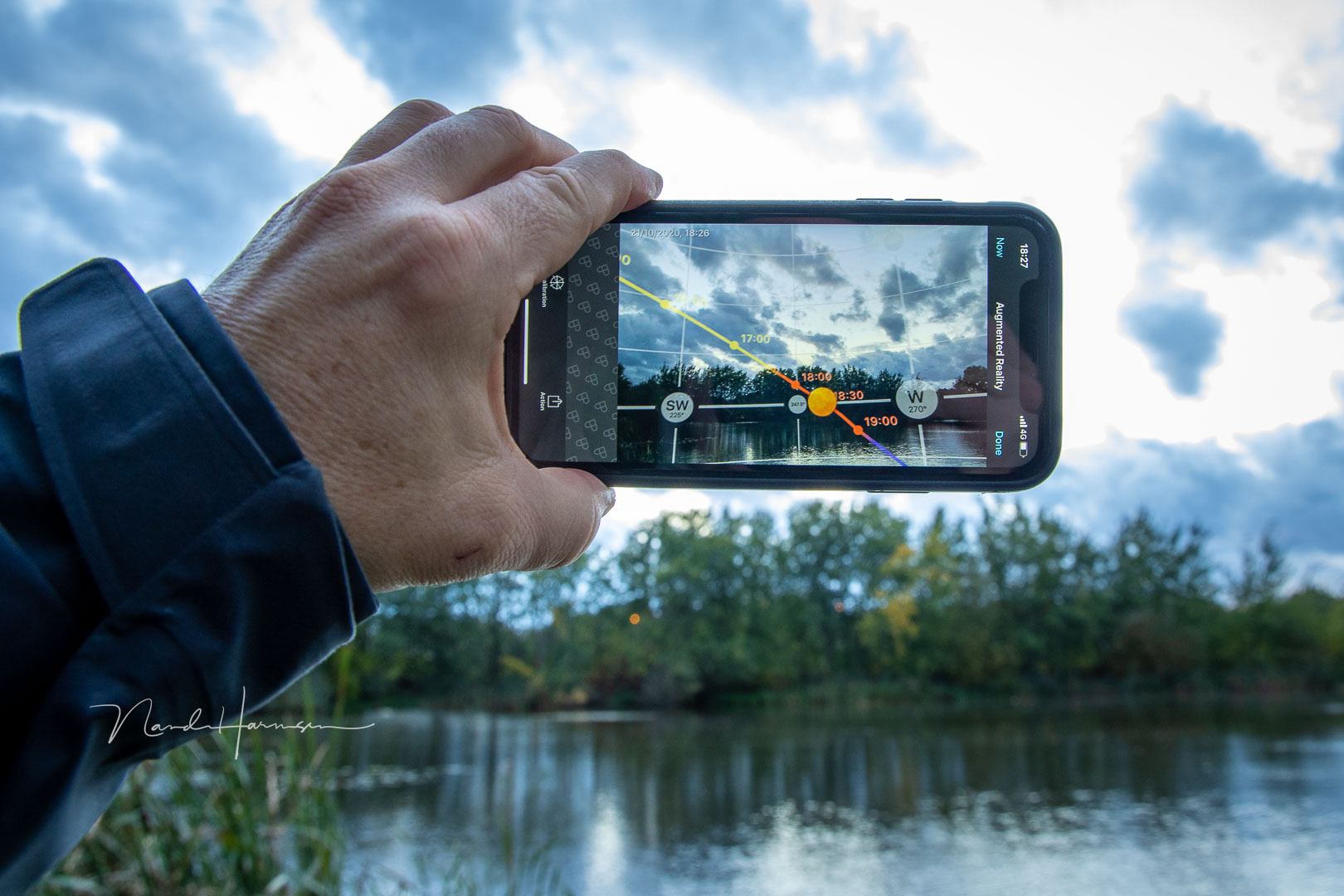
1. Photopills
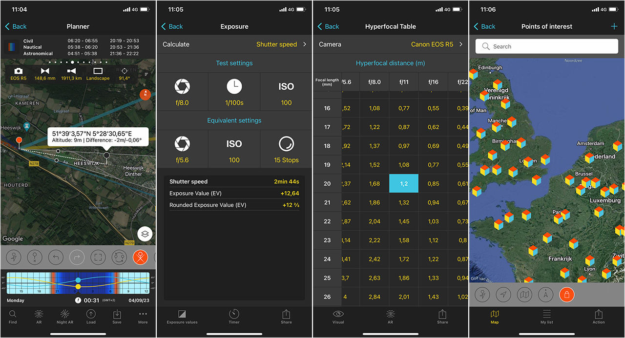
This is widely recognized as the go-to app for landscape photographers. Photopills offers a plethora of features, which include depth of field calculations, field of view information, hyperfocal distance tables, time-lapse assistance, star trail planning, and much more.
It also provides detailed planning tools for Sun, Moon, Milky Way, and meteor showers. You can even create a list of points of interest, which is a feature in Photopills that is often overlooked.
The app is so extensive that you need to read the available manual or follow the instruction videos to fully understand its potential. While Photopills is not free, its reasonable cost is well worth the investment.
2. Tides
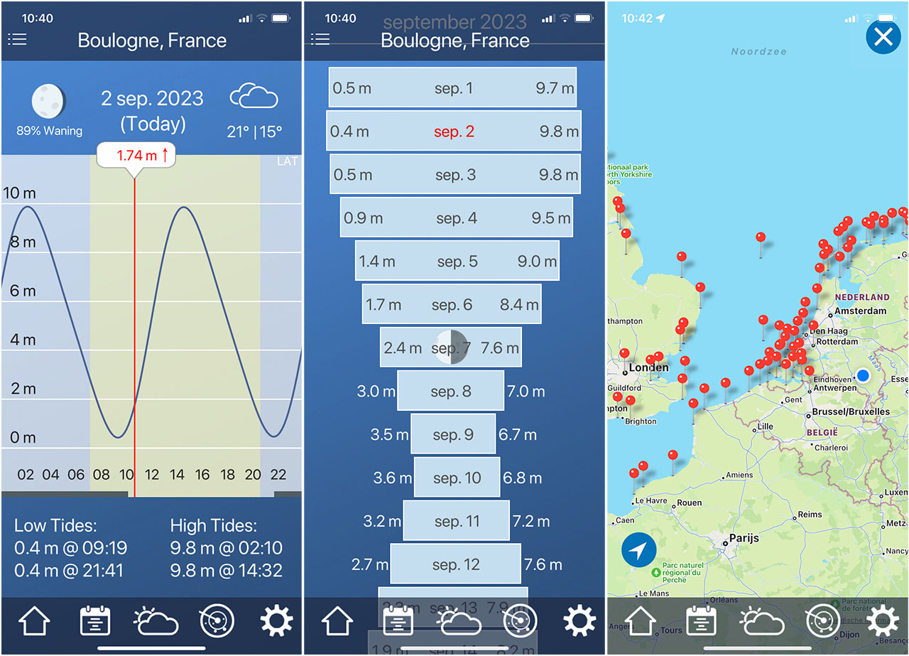
For photographers spending a lot of time near the coastline, knowing the tides is essential. The app Tides is a simple yet effective app that provides the necessary tide information for safely photographing at the shoreline.
Although it does display some advertisements, these can be removed with a small fee. The app is user-friendly, has a simple interface, and it uses GPS coordinates for the nearest tide information station. Although there are more detailed apps available, these are often designed with naval use in mind and come with monthly subscription plans.
The app Tides is made by 7th Gear, in case you have difficulties finding it.
3. Clear Outside
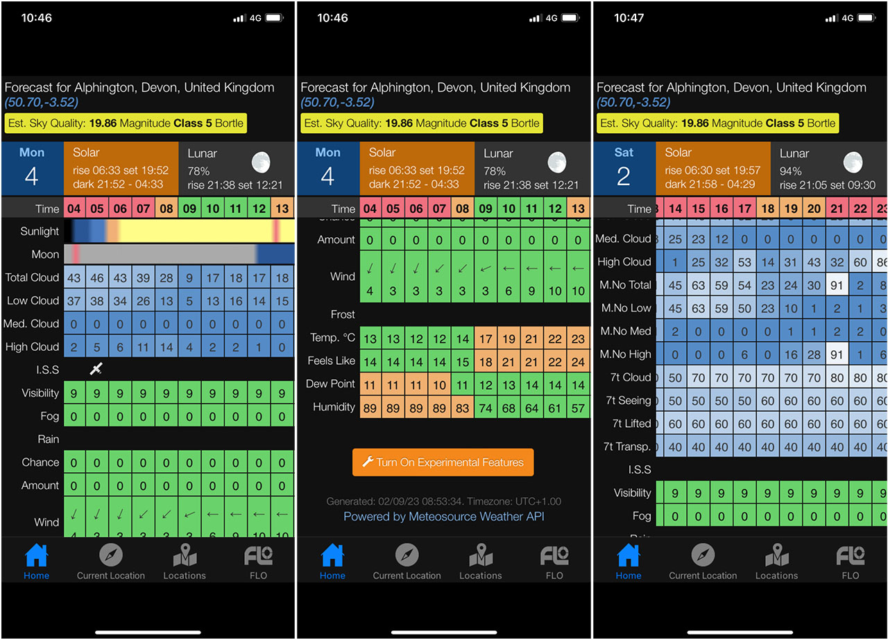
Unlike typical weather apps that provide basic temperature and precipitation forecasts, Clear Outside offers detailed weather information, specially designed with photographers in mind. It includes cloud cover at various altitudes, temperature data, dew point, fog probability, and much more.
There are no fancy icons and animations, which makes it perhaps less appealing compared to many other weather apps. The app shows a simple table with probabilities, which serves its purpose effectively.
One small caveat is that it defaults to a location in Alphington, Devon, UK, so you'll need to set your own location before using it, unless you happen to be in Devon, of course. Fortunately, it only requires one touch of the button Current Location to set the app to your specific location.
4. Yr.no
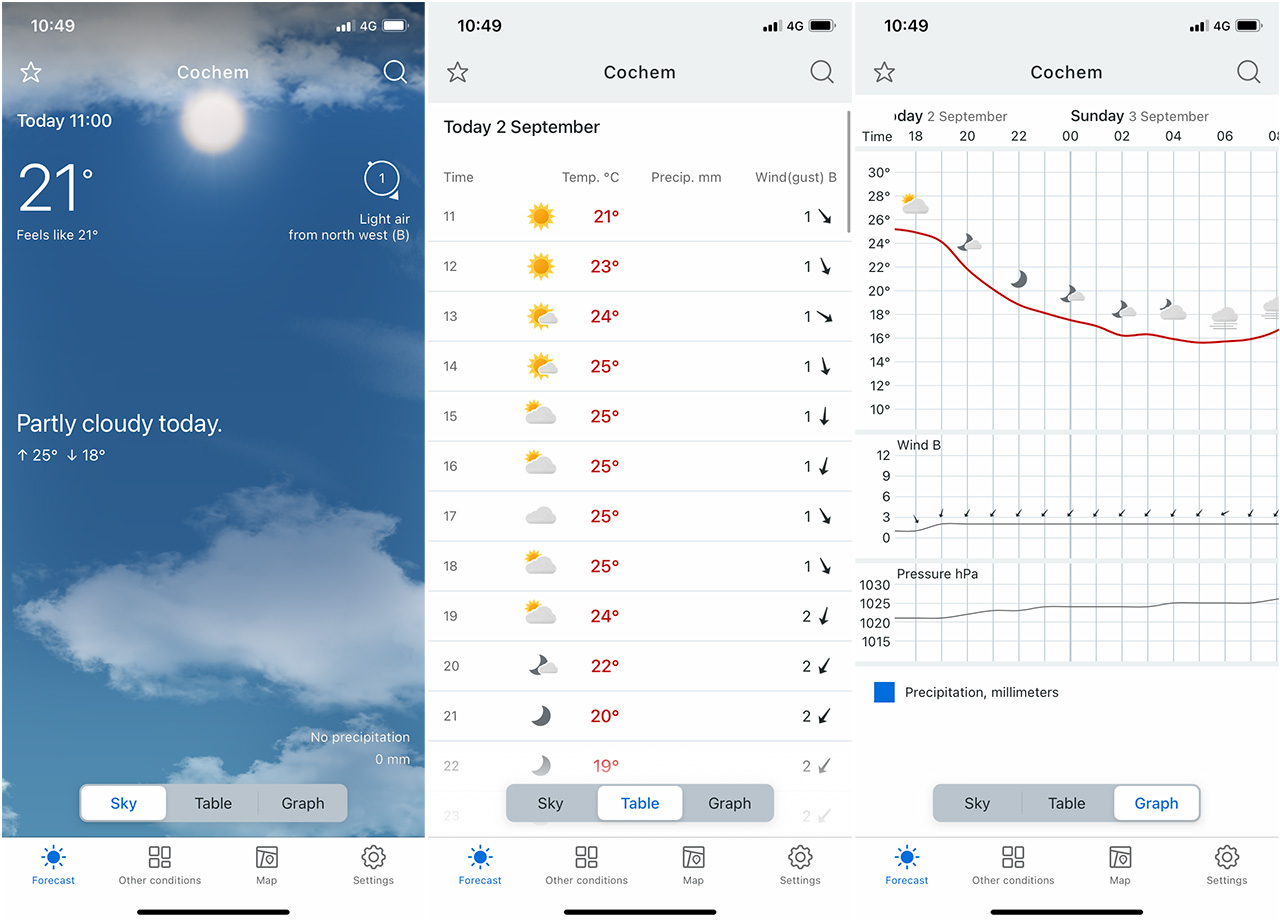
Yr.no is a straightforward weather forecasting app with a clean and uncluttered design. While its accuracy depends on various weather forecast stations, it generally provides reliable information. Additionally, it offers extra warning alerts, which can be particularly useful.
5. Maps.me
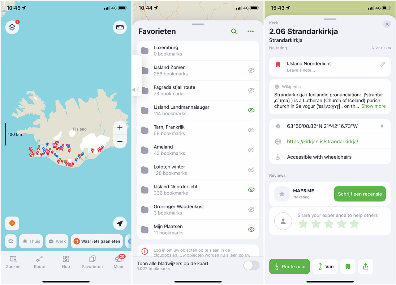
While Google Maps is excellent for typical navigation, it falls short when it comes to off-road or hiking adventures. Maps.me, on the other hand, is a great choice for such situations.
The app doesn’t make use of online maps. You need to download the map of the area you’re in, making it possible to use the app when you’re completely offline. This makes it a valuable tool for exploring remote areas, as long as you have GPS available.
The app also allows you to set points of interest and allows you to add additional information. Because it also displays hiking trails, you can use it for navigation purposes while hiking.
6. SpaceWeather Live
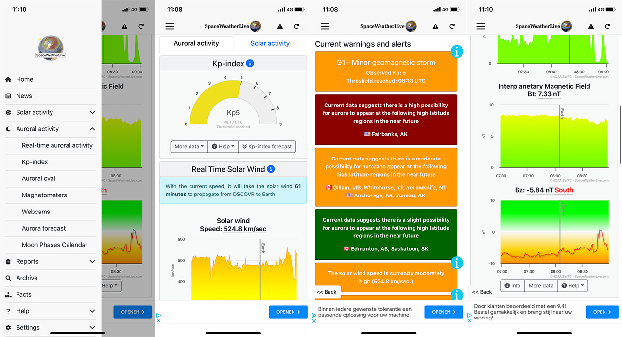
Aurora forecasting apps often prioritize visual appeal over providing precise information. SpaceWeather Live takes a different approach, offering a simple Kp index forecast along with detailed graphs illustrating solar activity and magnetic field measurements.
While it requires a bit of diving into the details, this app provides a deeper understanding of the predictions.
How About Other Apps?
The world of smartphone apps for landscape photographers is vast and continually evolving. While these six apps have proven indispensable in my photography journey, there may be other hidden gems out there that I'm not aware of. For instance, I’m searching for a good detailed light pollution app without unnecessary clutter.
If you know of any no-nonsense photography apps that have greatly benefited your work, please share them in the comments below. Describe their purpose and what makes them great for your landscape photography. I’m looking forward to your suggestions.


Join the Fstoppers community for free
-
Post comments and join in the discussions
-
Browse the site ad-free
-
Share your work and get featured in the community
-
Compete in the photo contests for fun and prizes
25 Comments
Thanks for sharing! I love Clear Outside. I never seen it b4. I have a bunch of apps that I love and use. Alpenglow for sunset forecast. Exsate golden hour also a sunset app. Sun locator Pro another sunset app but this one you can use your camera for a live view of where the sun will set. Sun Surveyor is another sunset app and probably the one I've used the longest. MySunset is another prediction sunset app to try. I also use Google Earth to explore trails, it's more detailed than maps for planning a hike and the terrain. I also use AllTrails and onX Offroad for hiking and offroad stuff plus they work on the PC for easier planning than my phone. For weather apps I also have FlowX , Windy and now Clear Outside. Thanks again for sharing.
You mention a lot of sun information apps (aAlpenglow, Exsate, sunlocator, sun surveyor. Are you using everyone of those apps? Can you tell me why so many?
Well several of them haven't been updated. Also they all vary for their predictions as to what they use to try and calculate a good sunset. I've bought them in the past and still glance at them when I see from Windy and now Clear Outside showing the high clouds where I plan to shoot. But long story short, they rarely predict an accurate sunset. Alpenglow on IOS has the sunset simulation to show where it will set with your gps location. The developer told me it was coming to Android as well, but that still hasn't happened. I basically try them all and if I buy them for a few bucks, I tend to collect them....:P
I have seen the same thing with the app Light Pollution Map. It worked fine up to a few mounths ago. It wasn't updates for years, while still offering a 10 dollar pro account. Fortunately Apple refunded the money since the app refused to work.
I try to keep the apps to a minimum.
Although all the functionalities you mention are present in Photopills, I will have a look at Sun Surveyor, since it's mentioned a lot in the comments
I like Photopills and it actually has pretty much the same thing Sun Surveyor has. I had Surveyor purchased already and then found Photopills. As for the sunset apps, I tried them each again Monday evening as we had a really nice sunset. Fotocast, Clear Outside and Alpenglow all failed at prediction. Actually Clear didn't predict the high clouds. MySunset app predicted a 94% for a great sunset. I can do better than all my apps at predicting. If I leave my camera and get stuck inside, I can predict that it will be an amazing sunset. Lol.
I already use PhotoPills and Clear Outside, but add in Planit Pro, Stellarium +, Skyview, Sun Surveyor, Light Pollution Map, and Windy.
I have stellarium as well, but I rarely use it since I know most common constellations by heart. I will check out the other ones you mention.
I would definitely add Windy - such a great tool.
Gaia is super handy - I use it all the time while hiking - both to get to where I am going and back. Plus waypoints for when I find something interesting, but might want to photograph it in different conditions.
Just wanted to write the same... Windy app is superb for wind and tidal prediction, swell and so on... Using it for longer than 5 years and never seen anything similar. Great app for android and iOS
Windy needs a yearly subscription to see the tides. Which is unfortunate since I don;t need the extensive details about wind patterns it offers.
I will keep the free version for a while, to see if it has any benefit for me. Thanks for mentioning the app.
I just found out there is 2 versions of Windy for Android. One is Windy.com (the one I pay for) and another Windy.app. Windy.app actually looks really good but more expensive than the .com one.
For travel landscape: Maps.me (or another gps with downloaded maps and the option to put your own location spots in it) is easy nr. 1 for me. That's where the travel starts and it's unthinkable to ge without.
A few good weather apps (depending on your location which to use) and you are good to go.
I can't figure out why I have such bad luck with Clear Outside but for me using it mostly on the NE area of the US it is horribly wrong a lot of the time.
I think the app is using local weather station information. If that information is outdated or wrong in some way, the predictions are also incorrect.
But I believe local situations, like buildings, forests and other large structures can influence the predictions. Just like it is warmer in a city in winter, compared out in the fields.
Photopills and ClearOutside are already on my list.
Light Pollution Map for checking light pollution: https://play.google.com/store/apps/details?id=info.lightpollutionmap.mo…
Stellarium for checking the night sky: https://play.google.com/store/apps/details?id=com.noctuasoftware.stella…
I'd recommend OSMAnd for offline mapping. Uses Open Street Map and Wikipedia data: https://play.google.com/store/apps/details?id=net.osmand
I've installed Light Pollution Map now. It does look like the one I was searching for. Thanks for mentioning this one. Stellarium is also one I have installed many years ago. But I know most constellations by heart. So I don;t use it that often.
Happy to help!
A couple of apps that you may want to consider instead of Clear Outside are Astropheric and Xasteria. Both are astrophotography apps on iOS.
Thanks. I will check it out.
I'll mention Sun Surveyor, excellent app also
Astrisoheric has been great for me. Predicts cloud cover, light pollution, smoke ground temp, wind visibility.... Great tool for more than just astro. Photo Pills is great. Also Ephemeris - I use the website on my desktop quite a bit too to plan sunset or sunrise shots.
I think you meant Astrospheric. Unfortunately it's not available in my country. Don't know why
Yes, sorry for the typo. It's been a great tool for me. The website works well too when planning ahead.
Thanks for the clear outside tip. Simple and useful app that I didn’t know off
Glendale is a chrome app, whatever that is, and is excellent for aurora forecasts as well as live reports from users, which are particularly helpful because of local weather variations.