
I’ve been making a tutorial about the Map Module in Lightroom Classic for the Dutch Photographic community. It can be a lot of work collecting and adding GPS data to your images. Does this information have any use at all, or is it just nice to have?
It may be helpful to know where a photo was taken. Perhaps you remember it very well, but as time passes, the memory can become less clear. Especially if you travel a lot, it may become difficult to know exactly where the place was, should you return one day.
You can keep track, of course. I used to write the location in a photo album, and often, the exact place wasn’t that important at all. But with GPS built into a camera, it is possible to record the exact spot where you stood when the image was taken. It can even record the altitude.
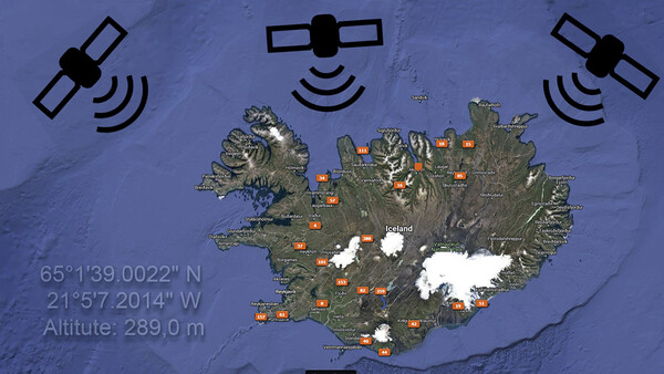
A GPS Module Inside the Camera
The Canon EOS 7D Mark II has GPS built in, just like the Canon 5D Mark IV. Sometimes, I used it, sometimes, I simply forgot to turn it on. The nice thing about built-in GPS was the automatic tagging of the coordinates while photographing. Now, I have the Canon EOS R5, which doesn’t have GPS built in. You could say that’s a shame, but if I think of the number of times I needed the coordinates that were recorded with my previous cameras, it doesn’t really matter. Not for me, at least.
Using a GPS Data Logger
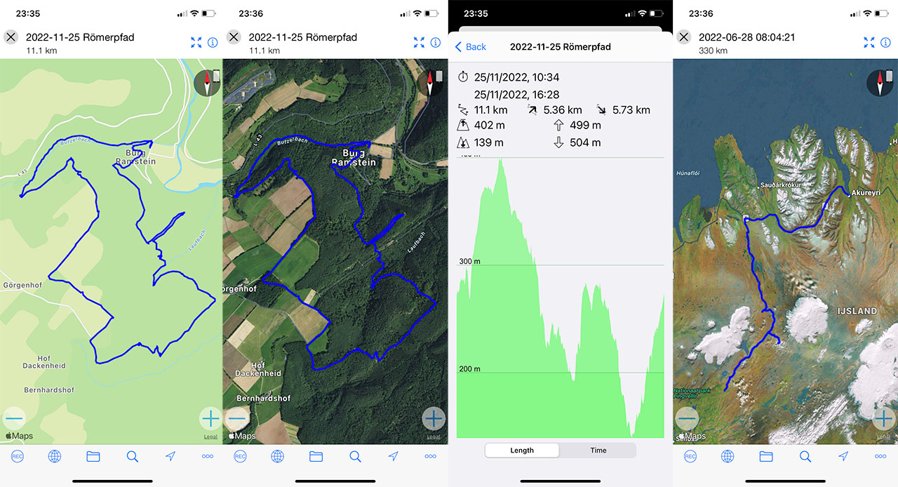
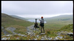
There is another way of recording GPS coordinates. With a GPS data logger, your hikes can be recorded. Synchronize the time of the GPS data logger with the camera, and it becomes easy to retrieve the coordinates afterwards.
Instead, I installed a simple GPS data logger on my smartphone. It does the same trick, although I don’t like to be dependent on the smartphone for so many things. I would prefer a separate GPS data logger, if I could find one. But it works, and the app on my smartphone records my travels. This way, I can place the coordinates in the EXIF data afterwards.
The Map Module in Lightroom Classic
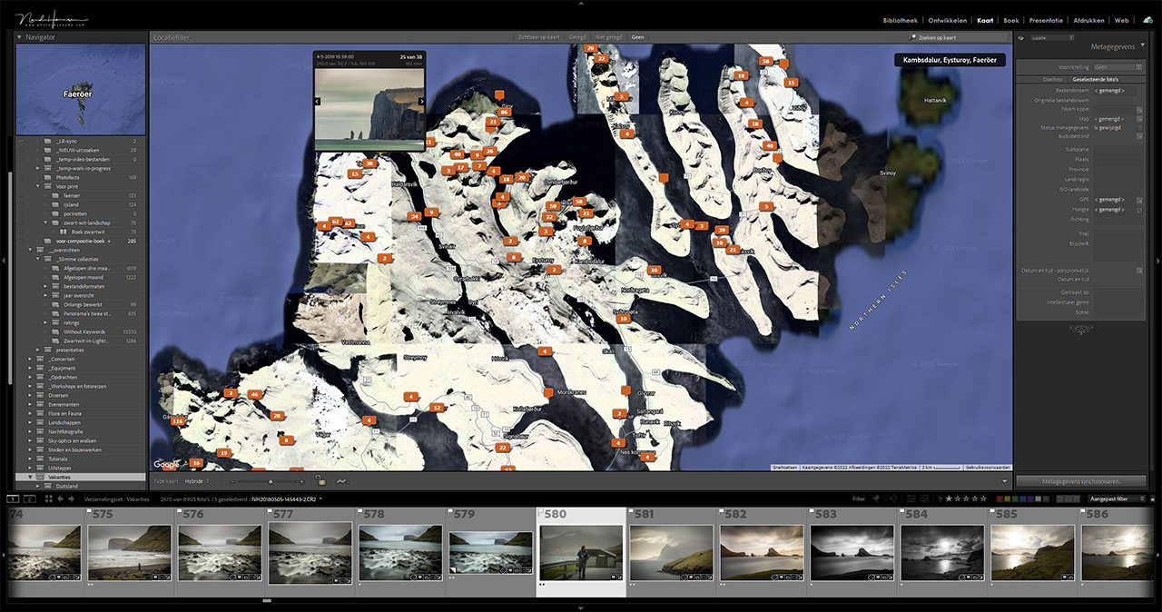
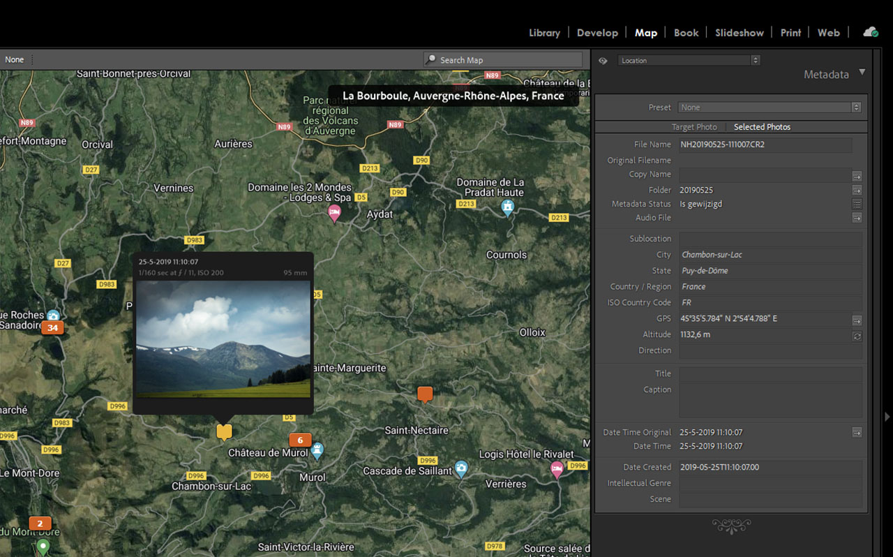
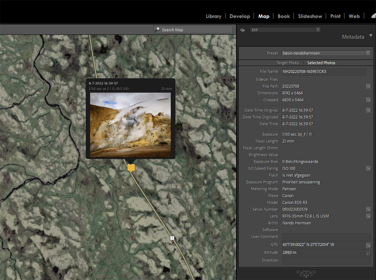
I use Lightroom Classic to manage my photo database. It has a map module built in, something that’s often overseen. If your photos have GPS coordinates, the software will place the image directly onto the map.
Lightroom Classic allows you to import a GPS data track also. You have to be careful, though, because if you have passed through any time zones, you need to correct the imported data track by the amount of hours. If you do, it’s easy to tag all images with the correct GPS coordinates with a single push of the button, so to speak.
I’ve done this for my photo travels to Norway, Iceland, France, and Luxembourg, I recorded the GPS coordinates every single day and imported the tracks into Lightroom Classic. This way, the GPS information was placed in the EXIF data, and Lightroom Classic automatically added additional location information.
Now, I know where my photos were taken. I can trace my travels in the ,ap module inside Lightroom Classic and… well, that’s it, really. I can’t think of anything else to do with the information besides looking at the Map module.
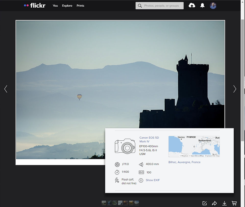
With every export, the information is added to the EXIF information of the JPEG image. The information is read if I upload the image to my Flickr account, and people can extract the precise place where that particular image was taken. Of course, I can decide to remove the location information during export, as Lightroom Classic gives you the choice.
Do You Need All That Information?
It can be nice to have a complete set of EXIF data for every photo: the exposure settings, what kind of lens and focal length you used, the brand and model camera, and, of course, the time and date. The coordinates can be added, just like the location info. If your camera has a built-in GPS module, the coordinates will be added without putting extra work into it.
But if you need to use an app or a dedicated GPS data logger and you need to do all the extra work of importing data tracks and synchronizing the timestamp for a bit of information, which is probably almost never used again, I wonder: what’s the use? Isn't it just a waste of time?
There are a few times, though, that the coordinates were useful for me. I’ve been scouting for locations in France for my upcoming photography masterclasses. In this case, it was very handy to have the information at hand. It makes it easy to see where the best locations are and if they're suitable to my needs. On the other hand, I was also making notes, and I had done some homework to find a lot of those locations. I already knew where they were located.
Besides that, I still have my smartphone at hand, not necessarily as a GPS data logger, but to take some quick snapshots. Those also have GPS coordinates, making locations almost always traceable. I almost forgot to mention a drone, which relies on GPS to find its way. The photos taken with these devices also carry GPS information within.
Perhaps It’s Not That Useful After All
GPS coordinates for your photos is a nice thing to have, and even without a built-in GPS receiver, it’s easy to get the exact coordinates for every photo you take. Software like Lightroom Classic will help in placing the images on the map. I think it’s a good thing that this is possible.
Alas, I can’t see much benefit. What's the use? On top of that, if you want to prevent the exact location from being openly available when using an image online, you need to take precautions to remove that piece of EXIF information.
Perhaps there is a good use of GPS coordinates for your photos. If you have a reason why you should go to all the trouble of adding this information to the EXIF data, I would love to hear about it. And while you’re at it, let me know if you are using GPS coordinates yourself in the comments below and why. I'm looking forward to your response.


Join the Fstoppers community for free
-
Post comments and join in the discussions
-
Browse the site ad-free
-
Share your work and get featured in the community
-
Compete in the photo contests for fun and prizes
17 Comments
With regard to GPS Data & the Canon R5, if one uses the Canon Connect App, the camera will record GPS exif data seamlessly. I personally use GPS data in Lightroom Classic to find photos as an extension to the other available data.
Downside is the requirement of a connection between camera and the app. If the connection is somehow lost, you need to reconnect. So again after switching off the camera, or if you have used wifi with your smartphone, or if the distance between camera and app becomes too large.
I use the Canon Connect App with a KP and never have a connection issue, never dropped. My phone is in my pocket and my camera in my hand.
May I ask, what's a KP?
Should be "RP" (though I also have a Pentax KP).
Thank you.
I've not made use of GPS data yet - I always thought that I'd take a geotagged snap with my phone if I thought I may need help remembering the location... Been caught out by that quite a bit, so a tracker sounds like a winner!
My current cameras don't have GPS and the Sony software only allows me to connect to one camera at a time to tag location. Not good when you've got a short lens on one and a long on the other.
What GPS tracker do you use?
With regard to the value of the data... Who knows what data may be needed in the future and if it isn't there it can't be used. Besides storage is cheap.
He uses the MyTracks iOS app.
The first time I went to India I spent a month roaming around in unfamiliar places. When on foot, I used Google Maps and I generally knew where I was. When I was riding around in a rickshaw, cutting through tiny streets and narrow alleys, I never knew where I was. Now I regret not recording GPS tracks if for no other reason that it would allow me to return to some areas that I would like to photograph again. But just having the tracks isn't good enough. I need to know where along those extensive tracks each photograph was taken. So yes, GPS data embedded in photographs does have some utility to me, even if it means setting up a preset to remove it before posting images to social media.
This post reminds me of the arguments about the utility of providing EXIF data when posting images online. "You can't draw reliable conclusions from them anyway," is the reasoning I usually hear. But to me, EXIF data or GPS location data doesn't have to have utility to justify recording it. It just has to be interesting. I like to see EXIF data when photographs are posted because I find it interesting. I like to save GPS data because I find looking at a map in Lightroom with photographs geolocated interesting. For me, that is reason enough.
Just curious, I noticed on my 7D, Mk IV, the battery loses power much faster with GPS on. I have not found the importance of GPS other than just having that info.
Indeed, it has an effect on battery life. The 7D II is effected more compared to the 5D IV, I remember.
I do use GPS logging for one main reason - It's much easier to check that location months/years later when I want to return to the place I took a particular shot. I shoot the Lumix G9 which does permit adding GPS data to any image through the Panasonic Image App, but with one huge caveat - the Panasonic Image App does NOT pass elevation data through to the camera. I recently had discussions with Panasonic on this topic because other apps that I use DO show elevation data, but not the Panasonic Image App. Panasonic admitted that the Image App does not pass elevation data on to the camera. I have requested that Panasonic correct this omission at earliest opportunity. As for heavier battery usage, if this concerns the photographer, get a power bank such as the Anker 337. This is the largest capacity power bank (26800 mAh) that one can fly with per TSA guidelines. This power bank will power both the camera and the phone or external GPS.
I periodically do aerial photography for conservation groups. I just recently incorporated Geo-tagging into my kit. Very helpful in the editing process and really useful for being able to separate private land parcels from public lands out here in the vast landscapes of the American west.
For me the GPS coordinates are the most essential information. I locate photos in my collection much easier by map than by any other information.
I geo-tag all my photos. Truthfully, for many photos, the location is not that important either because of the content or because the location is obvious. But for others, it is invaluable such as a multi-day backpacking trip.
My Nikon does not have a GPS so I use a Columbus P-1 or P-10 GPS data logger. Nothing fancy here, just a data logger. Turn it on and forget it (It has 2 butons+ power that I never use and no display other than a few flashing LEDs). Runs 50 hours on a charge and will go to sleep if it detects no activity or signal to conserve the battery (USB charge).
I match up the logger files (micro SD card, a full day is 200K) in Lightroom using Jeffrey Friedl's Lightroom Plugin. The logger files can be viewed in a number of matting applications (e.g. RouteConverter)
Thanks for the comment, Todd. I've been looking for a good GPS data logger for some time, but never found one that simple. Most of these are too fancy.
I will look into that Columbus P1 or P10. Any advise on which one is the best?
.
Precise GPS coordinates would be extremely useful for recording the exact location of trees with woodpecker nest holes in them, or of rocks that serve as snake dens, or scrapes and rubs used by Whitetail Deer bucks during the autumn rut. There are many things that I spend hours and days trying to find in the woods and marshes, and when I finally do find what I am searching for, it would be great to have the precise location saved to a file so that I could find it more easily the next time I go afield with my camera.
.