There are many things you can do during the lockdown from the comfort of your home while your photography work has dried up. Turns out, archeological discovery is one of them.
Today's modern technology undoubtedly makes the lockdown easier. We are able to continue being social with our friends and family as well as attend business meetings, but there are other ways it can be used while you're stuck at home, unable to travel. British photographer Chris Seddon, having found himself out of work as weddings and large gatherings have been banned, started filling his time by using maps and images to virtually explore an area near his home in southern Derbyshire, England.
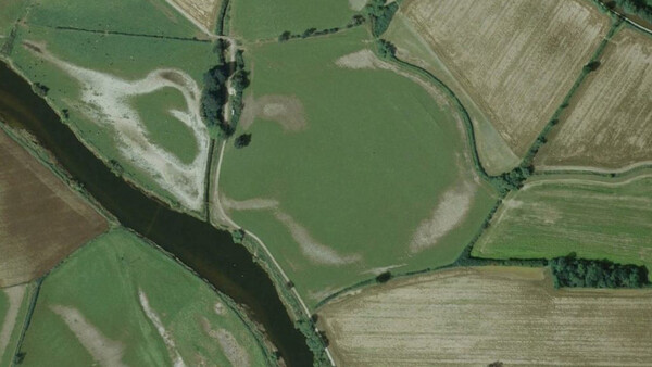
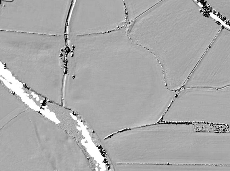
Looking at the area through aerial photos did not bring any new findings, but a LIDAR image did. It is a method which can produce 3-D modeling of an area by "illuminating the target with laser light and measuring the reflection with [a] sensor." This method can help reveal remains of a structure that once stood in the terrain but is now long gone. The photographer noticed something that sparked his interest near the village of Swarkestone, England. It was a circular formation, bearing a resemblance to Stonehenge. Although only visible as a faint formation in LIDAR images, the surrounding fields suggest that farmers may have arranged their plantings around the structure that may have once existed there. Furthermore, the area is known for other Neolithic sites, helping support Seddon's finding.
After his discovery, Seddon signed up for an online archeology course where he was able to upload his findings in a discussion group looking for feedback on whether this could be "a forgotten Neolithic monument, a former course of the river, or a modern drainage ditch." Turns out, the response he received from his academic peers and tutors was positive. Currently, no digging can be organized due to the lockdown, but Lisa Westcott Wilkins, who is a managing director of Dig Ventures, the online course Seddon signed up for, noted that it does indeed look promising, and it might be a significant archeological find once the professionals are allowed to go and explore it. If you want to try out LIDAR maps yourself and see if you can discover something new, you can use LIDARfinder.
Have you taken up any new or surprising hobbies during the lockdown?


5 Comments
I wrote a book and started to teach myself Calculus (I'm young for it). I suppose you could call those surprising.
I tried the LIDARfinder tool - but around where I live (Switzerland), there is no coverage. So I just looked at some random place in Wales, and look what I found (coordinates are 52°17'24.6"N 3°54'14.2"W) Looks like the foundations of a castle to me. But just guessing, I'm no archaeologist.
I just found that it was indeed a castle, but already known: Ystrad Meurig
http://www.ecastles.co.uk/meurig.html
(And I thought I made a huge discovery...)
I've got a feeling that archaeologists will have a long list of places to check out after the lockdown!
I spent many hours of undergraduate lectures scouring aerial surveys and LIDAR. I didn’t discover anything per se, but I did learn a lot about how the use of the landscape changes over time.
History is endlessly fascinating.