
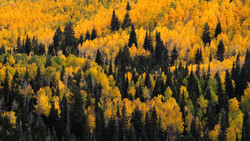
The team at SmokyMountains.com is back again this year with their updated prediction map for timing the peak fall foliage colors in the United States. Using this interactive map, photographers can easily find out the best time to take a trip out to the woods and capture the most vibrant and colorful images of the season.
How is the map created? SmokyMountains.com pours through the data points of NOAA historical temperatures, NOAA historical precipitation, NOAA forecast temperatures, NOAA forecast precipitation, historical leaf peak trends, and peak observation trends. The data is then placed in an algorithm that outputs around 50,000 predictive data points which can than be used to forecast on a county-by-county level across the United States.
Data Scientist Wes Melton, working with SmokyMountains.com, has good news for U.S.-based photographers: “Other than the Pacific Northwest, we are expecting warmer-than-average fall temperatures during the during the September through November time period. These warmer temperatures are expected to prolong the color season.”

The interactive map shows predicted weekly changes from August 13 through October 29. Next Sunday, September 10, the map gets its first taste of “near peak” colors, so plan and make travel reservations now.


Join the Fstoppers community for free
-
Post comments and join in the discussions
-
Browse the site ad-free
-
Share your work and get featured in the community
-
Compete in the photo contests for fun and prizes
3 Comments
Maybe a good followup article would be good locations to shoo the change in color? I'm actually looking into this right now as I'm a Florida native, we don't know what seasons are!
Come on up to Minnesota, it's ahhh-maaaaaazing! :)
Does something like this also exist for places outside of the US?