
Photographers across social media channels chimed in late this week as leaked documents were made public by the Washington Post on Thursday detailing the proposed size reductions and restructuring of both the Grand Staircase-Escalante National Monument as well as the Bears Ears National Monument in Utah.
Expected to be announced by President Trump on Monday in Salt Lake City, the proposed changes include splitting the Grand Staircase-Escalante National Monument into three national monuments while shrinking the overall combined footprint from 1.9 million acres to 997,490 acres. The three new monuments would be called the Grand Staircase National Monument, the Kaiparowits National Monument, and the Escalante Canyons National Monument. The Bears Ears National Monument would likewise be divided into two monuments – the Indian Creek National Monument and the Shash Jaa National Monument. With a combined size of 201,396, these two new monuments would be a significant reduction from the current 1.35 million acres of the Bears Ears National Monument.
These proposed changes are ultimately the result of federal, state, and local government officials in Utah who have lobbied for the lands to be opened up to development. The New York Times reported that the Grand Staircase-Escalante National Monument holds the largest coal reserves in the country with the Kaiparowits Plateau containing at least seven billion tons of coal at a value north of a trillion dollars. Conoco Oil, which owns drilling leases on 140,000 acres within the monument, believes that there are hundreds of millions of barrels of oil available as well.
Plans for coal mining and oil drilling in the region are not new. Going back to the early 1960’s there have been numerous efforts to seek approval for full-scale operations. None have succeeded. In an effort to curb any further debate, in 1996, President Clinton created the Grand Staircase-Escalante National Monument all but shutting down the possibility of industrial development. However, with his planned pronouncements in the coming week, President Trump will attempt to abolish a large section of the monument. Many believe he's acting without proper authority. Here’s the situation. In 1906, the Federal Government created the Antiquities Act which grants sitting presidents the power to create national monuments. It also gives the president the power to eliminate or reduce them as well. In 1997, Congress passed the Federal Land and Policy Management Act which seems to go against the Antiquities Act by reserving the power to modify or revoke national monument designations for Congress itself. Given these seemingly conflicting laws, it looks as if there will ultimately be an extended legal battle likely ending with a trip to the United States Supreme Court.
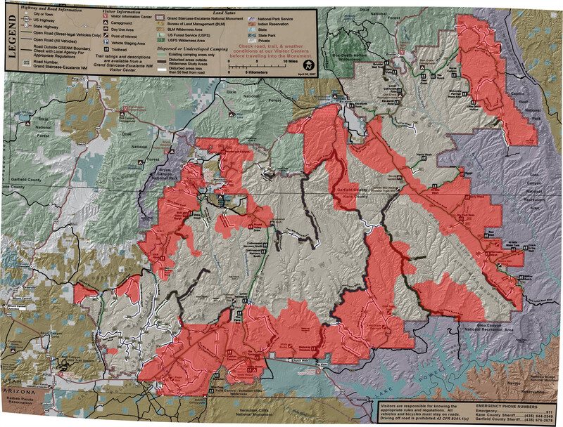
To help understand the impact of the possible changes, David Kingham, a photographer and photography workshop leader, posted a helpful map today on Facebook showing the current Grand Staircase-Escalante National Monument and the proposed reductions. David notes that some key areas within the monument will presumably revert back to the Bureau of Land Management including Dry Forks Slots, Sooner Rocks, Sunset Arch, Toadstools, and Smokey Mountain Road.
Why does any of this matter to photographers? The most significant reason is that within a 200-mile radius of the Grand Staircase-Escalante National Monument are many of the nation’s most prized national parks and recreation areas including Bryce Canyon, Canyonlands, Capitol Reef, and the Glen Canyon National Recreation Area. Mining, drilling, and power plants could have an adverse impact on not only the immediate area around the Grand Staircase-Escalante National Monuments but these other scenic parks as well.
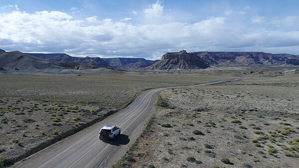
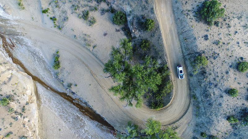
Having recently driven and explored the nearly 100-mile overland route from Big Water, Utah up to Hole-In-The-Rock Road near Escalante, Utah I can personally vouch for the pristine and spectacular beauty of the region. The drive begins after crossing Wahweap Wash, entering an area the local geologists call “The Moon.” The grayish landscape is technically known as Tropic Shale.
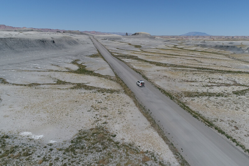
In exploring this area, you will find a remarkable amount of ancient mollusk shells (mostly oyster shells), some shark’s teeth (if you know what you’re looking for), and on rare occasions, dinosaur bones. It may seem strange to find these aquatic artifacts in the middle of a desert but around one-hundred million years ago this entire region was near the shoreline of a giant inland sea called the Western Interior Seaway. All of the organic material from that era is what has made the area so rich in coal and petroleum in the present day. Progressing along Smokey Mountain Road you get a sense for how it got its name. The light smoke and haze that can fill the air are from those plentiful coal reserves. Interestingly, lightning strikes ignited the underground coal and it has burned unchecked for at least a century. Next, the Kelly Grade carries you up from the otherworldly Kaiparowits Basin to the plateau where the vistas from the top are simply spectacular. From there travel is across miles and miles of rugged and remote terrain spotted with mesquite shrubs, pinion pines, and extremely large boulders.
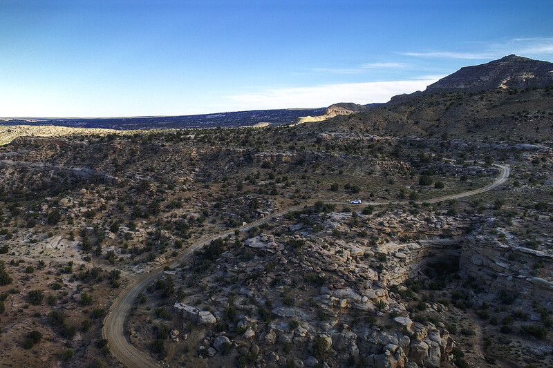
Along the way, there are countless photo opportunities including some lesser visited arches and Anasazi granaries. The final few miles of the journey, along Left Hand Collet Canyon Road, is in a deep canyon with sheer walls going by just outside your window. At the top, nearing Hole-In-The-Rock Road, is an interesting place to stop called Twenty Mile Wash. Here the tracks of dinosaurs reveal themselves in faint relief atop the sandstone rock. They are fun to explore but difficult to photograph. Once at Hole-In-The-Rock Road there are slot canyons, crazy rock formations, and many other places to explore in either direction. All-in-all it is a fantastic photographic journey that can be made in a day or a week, it really just depends on the pace you want to set.
It would be extremely sad to see the unique landscape around Grand Staircase-Escalante be altered for all time due to coal mining and oil drilling operations. It would be exponentially more disappointing to allow industrial development to impact the natural beauty of the surrounding parks. National treasures, which have been set aside for the enjoyment of all, could be changed forever if we don’t tread lightly and deliberately.


Join the Fstoppers community for free
-
Post comments and join in the discussions
-
Browse the site ad-free
-
Share your work and get featured in the community
-
Compete in the photo contests for fun and prizes
29 Comments
Uh oh! Thanks for the heads up! Random question, are all of those drone shots from inside the parks?
They were shot inside the national monument. In case you are curious, the monument is managed by the Bureau of Land Management, not the National Park Service. As such, flying a drone is permitted. You have to be careful near the beginning of Smokey Mountain Road however since it is very close to the Glen Canyon National Recreation Area where UAVs are not permitted to fly. That said, and even though it is fully legal, I try to fly in remote areas where the likelihood of disturbing anyone is slim.
Thanks for bringing more attention to this Steve. Big rally today at the Utah State Capitol to protest these changes, and there will be another on Monday when Trump is in Salt Lake to make his announcement.
You’re welcome. It is important not only to photographers but, in the bigger picture, to the generations that follow.
Is there a general consensus among Utah(ites?) on this issue?
Utahans (I looked it up :-) ) should make the decision. Since these things have to be decided by government, at some level, I think locals should have a larger say, if not the whole say, in such matters.
Utahans is way cooler than Utahites. Thanks for the clarification! I generally agree with what you're saying, I'm interested in any Utahans' (dang, I love that word!) take on it.
Almost makes me want to move to Utah. Almost. ;-)
Haha. Never been, but boy does it look stunning out there.
I've driven through a few times. It kinda gets lost among the more famous sites in that part of the country. When I drove through, about 40 years ago, I spent more time looking for Marie Osmond than picturesque landscapes. :-)
If it makes it to the Supreme Court, guess who controls that as well. Basically, kiss your views goodby.
It”s a good point but my suspicion is this issue will outlast the Trump presidency. The next president may be able to unwind it before it gets to the Supreme Court.
This bothers me. The rest of world is moving to solar, wind & other forms of renewable energy, yet here in US we are trying to dig up more coal & drill oil ?
You should defend your POV on the merits, not by saying, 'they're doing it so we should too.' Maybe solar and wind will be practical someday but not today. I'm more of an "all of the above" kind of guy.
Wind power is practical enough in Germany that they are producing so much wind power, that paying its people for using it.
Really? I'm surprised. Here, in the U.S., we have a lot of flat, open areas where you would think it would be more effective but it adds very little to the overall supply. Maybe the needs are much more modest in Germany!?
I live in Iowa, where we manufacture most of the country's wind turbines. We have one in a 50 mile radius of where I live. With all the open farm land thats around us, I am amazed we don't have more wind power here.
Oops! From your previous comment, I thought you lived in Germany. :-) There're a lot of them in northern Indiana (I drive along I-65, between Indianapolis and Chicago, every once in a while) but they rarely turn and usually pretty slow. I actually think they can be kinda photogenic but I guess they take out a few raptors occasionally. Again...not much electricity being generated.
66.5 percent of Utah is Federal land - think about that. How much of a State do you think the Federal Government should own and control? Bears Ears National Monument hasn't even been around for a year yet, and even though Grand Staircase-Escalante National Monument has been around since 1996, it's 1.9 million acres.
That is not even true. Why is it so hard for people to do objective research? It is so easy to find out the correct figure using google. I'm going to let you try again to see if you can do it and maybe in the future you can use this google skill you might develop to stop spreading misinformation. I'll also give you a hint, it is less than 50%.
Also in the case of Utah, our neighboring states pay the price with all of our pollution that blows into those states. Our government doesn't have a good track record regulating heavy industry and we have just about the nastiest air in North America. It is worse than Beijing on a lot of days. It is absolutely pathetic and has proven that Utah cannot even govern itself as our politicians are way too greedy to do that.
I actually believe Mike is closer to being right: The Congressional Research Service quotes the number at 63.1% (as of March, 2017). Page 8: https://fas.org/sgp/crs/misc/R42346.pdf
You may have been referring to the total federal land in the West, which was quoted by the NYTimes at 47% https://www.nytimes.com/2016/01/06/upshot/why-the-government-owns-so-mu…
The Antiquities Act has often been controversial with regard to accusations of Presidential over-reach. In fact such past controversy is the reason that the act now only applies to 49 states. People in Wyoming were outraged when FDR created the Jackson Hole MN. A flurry of legal challenges ensued and became a real headache when the government wanted to roll the land into what would become Grand Teton NP. Harry Truman and Congress ended the stand-off by exempting the whole state from the Antiquities Act and requiring Congressional approval for the creation of any future national monuments within the state's borders.
http://trib.com/news/state-and-regional/antiquities-act-turns/article_1…
Interesting information Geoff, thanks for sharing it!
Fascinating. I was not aware of this. Thanks!
Thank you for sharing this, it means a lot to me. Some of my family is out there protesting it.
I wish I could be out there with them. I am there in spirit though!
You should go out and document it so you can write a follow-up article! :-)
I appreciate the post -- as the start of a real discussion. But I think folks also need to have some awareness of other points of view -- at least if we're going to come up with a balanced solution. The fact is that plenty of folks in Utah are angry about how much of their state is under Federal control. That's one reason why so many Utah senators and representatives have been pushing this initiative.
The extraction industries have been a major source of income for generations in Utah. And even in Moab, home base for tourists visiting Arches and Canyonlands, lots of long time residents want to have another source of income beside tourism. So when a president takes 2,000,000 acres out of the state's control -- and does it without any feedback from the state's leaders, there are going to be hard feelings.
At the same time, folks in the state are hugely proud of their parks. When you visit Bryce or Zion or Arches, you run into lots of locals. They know tourists don't want to see coal mines or drilling right next to these natural wonders.
I personally think Trump has gone about this the wrong way. But if Obama or Clinton can create a National Monument with no outside feedback, they're doing our democracy a disservice as well. The best thing at this point would be for folks on both side to do two things, 1. Define which areas within these newer monuments are of true interest for the American people as a whole (instead of just setting aside a hundred miles of real estate) and 2. Define how far from the sacred treasures, and under what conditions, the mining folks can operate.
Excellent comment Tim. Thank you for providing this other point of view.