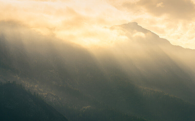
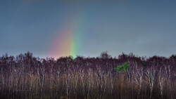
Rain, fog, red sky, hoar frost, and clouds: all these things are predictable with using apps. The only problem is that the probability that forecasts match reality is embarrassing low. I found a much better solution than I have used for some years now. With this, I’m nearly always fantastically prepared for the weather.
In my latest video about weather prediction for landscape photography, I show the problem with weather apps and even with common weather services. The core problem is that weather services just offer us values like five degrees, rainfall or not, maybe with a probability as a percentage. Some apps offer us even a probability for fog. But, we don’t get more than one version of the weather forecast.
Landscape Photographers Need Accurate Weather for a Specific Point
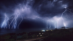
It is so important to consider that so many weather situations just happen locally to a specific geographical area. Sometimes, a bank of clouds, a rain front, or fog occurs just within a small area of 10 by 10 kilometers or even smaller. Predictions often come earlier or later. But a huge problem is that predictions often shift to different geographical locations. In my experience, this happens even in 70 percent of the cases.
Why Weather Apps Fail
Common weather services tell us maybe the probability for rain, 60 percent, for instance. But what would happen if the predicted rain front goes a bit more north so that it will not hit us anymore? Weather services don’t tell us how the weather will be otherwise. Weather apps simply don’t give us any scope of interpretation here. We are used to that embarrassing situation, so we don’t care about it. But what if I were to tell you that there is also a way to predict the weather for the missing 40 percent, so that you are always prepared for the weather?
The Forecast Method That Makes It Visible
We don’t need to understand everything about the weather, we don’t need to study. We just need the possibility to make as many versions of the weather prediction visible as possible, to cover most of the possible weather scenarios.
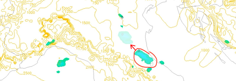
As I looked for more accurate weather forecasts some years ago, I stumbled over the possibility to interpret weather maps. It doesn’t only give us scalar values like degrees, the probability for rain or fog, and so on. It is a visualization of weather vectors that gives us much more scope of interpretation and reveals how the weather will be when the rain front would occur not at our camera position, but more 10 kilometers in the north, or wherever.
In the above-linked video, I show you how weather maps work, how you can read them, while you get many more tips about predicting the weather for your landscape photography so that you are always prepared.
Join the Fstoppers community for free
-
Post comments and join in the discussions
-
Browse the site ad-free
-
Share your work and get featured in the community
-
Compete in the photo contests for fun and prizes
19 Comments
Let's not forget to add the fire/haze app: https://fire.airnow.gov Also, I wouldn't trust the https://smokymountains.com/fall-foliage-map/ and this has been wrong 5 years in a row..
I agree. I live in Eastern North Carolina where you will receive several different weather seasons in a single day. Weather apps are generally always wrong. This isn't a big deal when I'm shooting still photography. I can generally make good use of all avaliable light or weather conditions. However it's especially problematic when I'm flying my drone for photography. Incorrect weather predictions have almost cost me several drones due to unforseen rains, fog and high winds.
Hi Roger, yes I know this problem too well :) The problem is simply, that weather services don't give us any scope of interpretation. You don't know how the weather will get when it doesn't come as predicted. Weather maps are the solution, they allow you to read between the lines. I will make a whole weather planning for my next phototour as a pro landscape photographer, using weather maps - and I will share everything of course. Stay tuned ;)
Nice greetings,
Christian
There is a good (german) book about weather prediction for landscape photography (Fotografieren mit Wind und Wetter) that really goes into detail how to read multiple types of weather maps for photography in different situations (golden hour, astro, fog, ice, etc.).
And then there is a great website for weather prediction: https://www.windy.com/
I'd really like to love windy.com, but I can't. Windy reports my city as 23C, unless you click on the "nearest weather station" button, in which case you get 27-29C. The official met service says 26.9C, my thermometer reads 28, but could be off by 0.5.
Why does Windy say 23 when none of the weather stations in my city are reading below 27? This means that it's not for me. Which really is a shame because it has lots of features and is really nice to look at.
Hi Jon, the problem is this weather service doesn't give you any scope of interpretation. You don't know how the weather will get when it doesn't come as predicted. Weather maps are the solution, they allow you to read between the lines. I will make a whole weather planning for my next phototour as a pro landscape photographer, using weather maps - and I will share everything of course. Stay tuned ;)
Nice greetings,
Christian
I am amazed - actually stunned - by how inaccurate weather forecasts so often are. As nature photographers, we benefit most from very precise weather details - like where three or four degrees one way or the other changes a world-class opportunity into a "why did I even bother coming here" waste of time.
I want info that tells me precisely what the weather will be in one tiny little spot. Telling me what the weather is two or five or ten miles away doesn't do me any good at all. And there is often a HUGE difference in weather from one place to another place just two miles away.
Yesterday I wasted 3 hours of my precious time because I drove to a place way up in the mountains to photograph a snow scene. The nearest weather station is over 12 miles away. It never said anything about 15+ MPH winds that blew the snow off of the twigs, branches, and pine needles. The forecasts for the nearest areas all said no winds over 8 MPH for 3 days prior to yesterday.
If the forecast would have told me about the windier conditions where I wanted to shoot, I could have stayed home and watched a football game. I missed that game because I went chasing a shot that wasn't there. Still a bit bitter and disappointed about that. And it could have been avoided if I had been given more accurate, more precise weather forecasting.
And don't get me started on 10-day forecasts which are completely useless trash. Basing equipment rentals on these things has been far more of a lose-lose.
Hi Robert, you can use longer forecasts over some days to find out tendencies. This gives you the prefix for your prediction. But you are totally right: the closer it gets to the time you want to photograph, the more accurate gets the prediction. I will make a whole weather planning for my next phototour as a pro landscape photographer, using weather maps - and I will share everything of course. Stay tuned ;)
Nice greetings,
Christian
Tom, it may not help all the time but try Windy and Clear Outside.
Eddie,
Thanks for the tip, but I am not sure what you mean by "try" windy and clear outside.
I've never used a weather app before - perhaps that is why I don't understand what you mean by "try" windy and clear. Do you mean that these apps that the author speaks of ask you to input specific conditions that you are looking / hoping for?
Any explanation would be helpful.
Thanks!
I used the apps windy and clear outside lots of times - and what should I say: sometimes they are right :)
The problem is the same with those: you don't have any scope of interpretation. The apps don't tell you how the weather will get if the prediction is wrong. This is why I use weather MAPS instead :)
Do you mean to say that one of the weather apps is actually named, "Windy and Clear Outside"?
These are two different apps, Tom. One is called "Windy" and one is "Clear Outside". They are not bad though, but they can never be that accurate as weather maps.
Hi Tom, you described exactly that situation I experienced for so long :) Weather maps made the big change for me then. I will make a whole weather planning for my next phototour as a pro landscape photographer, using weather maps - and I will share everything of course. Stay tuned ;)
Nice greetings,
Christian
Thank you for replying to me, but I must admit that I have no idea what "weather maps" are. Do you mean like when they show the thing on TV weather where it shows the current radar map of where the clouds and precipitation are?
Problem with those is that the only thing they show accurately is where the clouds / precipitation are RIGHT NOW. The projections that they show can be, and often are, slightly wrong.
And of course a slight inaccuracy can ruin an entire day of travel and photography plans, because we often make such plans needing a very precise type of weather, where anything even a little bit different will fail to give us the exact image that we planned our outing upon.
If there is any weather map that will show me EXACTLY what the weather is going to do for the next 24-18 hours in a remote location, then please tell me where I can find such a map! Because some of my plans and travel recently have been RUINED by the weather being a little different than what was predicted. I mean 2 1/2 inches of snow instead of 1 1/2 inches, 8 mph winds on a slope where a couple miles away the winds were 5 mph, etc. I really need very accurate forecasts to be able to get precisely what I have in mind. I am not a "just go with it" kind of guy AT ALL.
Hi Tom, no weather radar ist something different, this shows just the current situation weather. Weather maps instead show all the values, that got calculated for the forecast - in future - by the used weather model. It is a visualization of all the weather data, what allows you to read between the lines. A prediction is never perfect, but with using weather maps, I'm usually always prepared for the right weather, as I see "everything" that could happen.
Weather maps are shown in the mentioned video, also with a tutorial of how to read them. Look here: https://youtu.be/OVEmhCpEsOQ
Weather is also extremely important for me as a pro landscape photography. Interpreting weather maps is really the most accurate weather forecast method I know. I hope this helps ;)
Nice greetings,
Christian
Weather apps are really dumbed down forecasts. For example, a 60% chance of rain means that it may rain on 60% of the area nearby during the hour forecast. Wind is predicted the same way. But how large is the area? We need somebody to do it right.
Hi Steven, yes the resolution is quite high in many weather models. The problem is simply, that weather apps give us no scope for interpretation. I tried a lot of things over the years, but the one thing that made a big change to my weather planning was using weather maps. I will make a whole weather planning for my next phototour as a pro landscape photographer, using weather maps. Stay tuned ;)
Nice greetings,
Christian