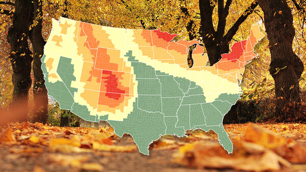
Just in time for the upcoming autumn season in the United States, here is the 2018 fall color prediction map to help plan your outdoor photography adventures.
This year's prediction map, created by SmokyMountains.com, shows fall colors developing in the U.S. towards the end of September with vibrant peaking starting in the second week of October in some areas. By November, most areas will be past peak and any remaining color will probably be happening on the ground rather than up in the trees.
Use the interactive map below to plan your scenic autumn travels.
The map's data is pulled from NOAA historical temperatures and precipitation, NOAA forecast temperatures and precipitation, historical leaf peak trends, and peak observation trends. A proprietary algorithm processes millions of data pieces to create the fall color prediction map. "Although simply entering rainfall, temperature data, elevations, and other data points into a model will never be 100% accurate, this combined with our proprietary, historical data drives our model to become more accurate each year," said Wes Melton, co-founder and CTO of SmokyMountains.com. "However, unexpected rainfall that falls well outside of expected trends can always change the peak foliage dates and brilliance."
Where is photography taking you this autumn season?
Photo by pixel2013 via Pixabay.


Join the Fstoppers community for free
-
Post comments and join in the discussions
-
Browse the site ad-free
-
Share your work and get featured in the community
-
Compete in the photo contests for fun and prizes
6 Comments
I just moved to Upstate NY and really psyched to see the autumn colors here. They were always lacking in KY and when I was living in UT there wasn't much their either.
You're going to love them. I grew up in the Albany area and the autumn colors in the Adirondacks are amazing.
I'm in Saratoga Springs and have been going up to either Lake George or the Adirondacks every weekend since I moved here. It's not the Western deserts or mountains but super nice on a different level and everything is very clean here.
I live in KY and some years seem very disappointing, but every now and then it will be absolutely gorgeous. It's odd how it's not consistent though.
Thanks for posting this Ryan
Oh maaaaaaaaaaaaaaaaaaaan I live in oklahoma and we have this spot called talimena national scenic byway and it is GORGEOUS in the fall. One of the few great things about this state. it's 50 miles long too. Can't wait to go!