
Living in the Southwest, I'm always out with my camera, looking for that great new vista just beyond the next curve in the road. For years, I didn't pay much attention to photo apps, because I was seeing stupid apps that put hats on people or distorted their faces, or worse.
Now, there are a lot of great apps that really can help photographers. In my own work, I concentrate on landscapes and night photography (star trails, Milky Way), and these are the apps for my outdoor work I really like. Some you may have heard of, some may be new to you. All have their place on your phone or tablet. I'm an iPhone guy, so the apps I'm discussing are iOS. When I can find the same or comparable app on Android, I'll point that out.
Magic Hour
Since many of my landscape photos involve setup before dawn or just before sunset, I'm always interested in when golden time (magic hour) is coming. Magic Hour (Apple App Store) is really my favorite app for doing this. It's free, although there is a $0.99 upgrade to get future details at different locations. I don't miss that feature, so free seems the way to go.
Magic Hour tells you when the best light is coming. It's helpful because golden time varies based on the time of year and where you are. You'll get the time of the best light, sunrise/sunset times, and the end of golden time. You'll also get a brief weather forecast with information on cloud cover, plus info on the phase of the moon and when it rises and sets.
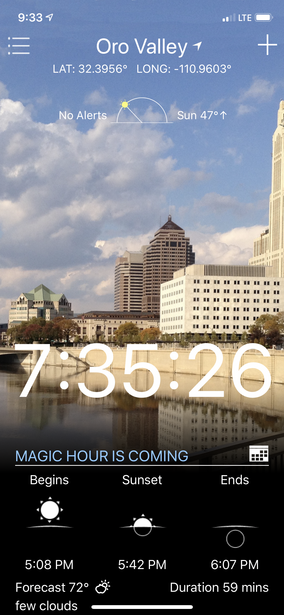
Photo Pills
If there were an Oscar for photo apps, I'd nominate PhotoPills ($9.99, Apple App Store, Google Play Store).
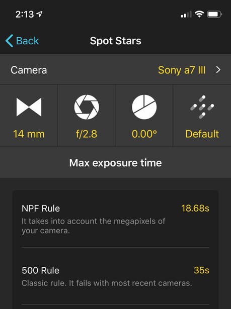
There're so many useful features, but I'll dive in with sun and moon information. Besides giving you golden time hours, it also provides times for blue hour, tells you when twilight ends, and when the sky is darkest. Speaking of those astronomical functions, PhotoPills will let you know how long your Milky Way time exposure should be before the rotation of the earth makes your stars look like sausages. Tell PhotoPills your camera make and model and the lens you are using. PhotoPills will tell you your longest safe exposure before stars get distorted by movement..
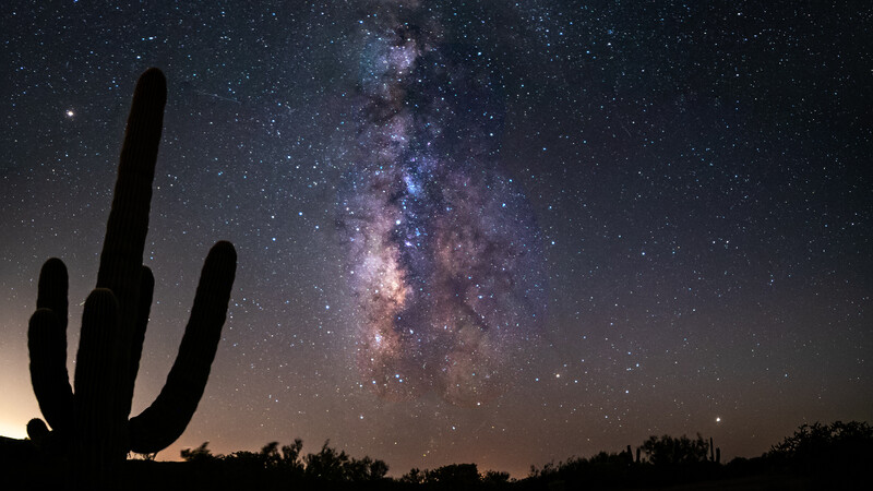
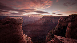
If that wasn't enough, PhotoPills will let you set up your camera gear before it gets dark so you can select some foreground objects if you like for your Milky Way shot. I did this in the photo below. Using augmented reality in daylight, I could see the cactus and position it to the side of the Milky Way, That way, no surprises when it got dark.
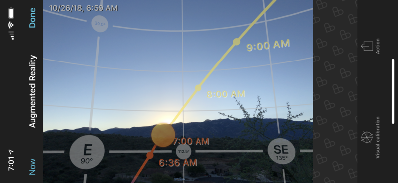
This also works for setting up your position to capture the sun or moon. In the screengrab below, all I had to do was point my iPhone toward the east, and the sun's position could be seen as it rose. Sure, I could take these shots without the help of augmented reality and did that for years, but as a planning tool and getting to just the right spot, it's a real joy. It's also nice for getting the moon just right, say under that natural bridge or partly obscured by that church steeple.
PhotoPills will also calculate exposure times when using neutral density filters, calculate depth of field, field of view, and even calculate how much space on your SD card a time-lapse will use if you input your shooting interval and the length of the clip you want.
TPE 3D
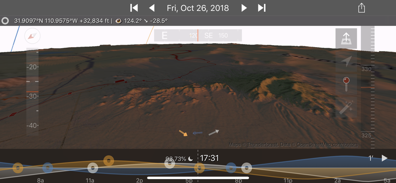
I'm also a big fan of TPE, The Photographer's Ephemeris 3D ($11.99) at the Apple App Store, (iOS only, but a version that doesn't compute shadows is available for Android here.) Like PhotoPills, it offers sun and moon positions, but in a really neat trick, it shows a 3D map and predicts where shadows will fall to aid in planning that striking golden time image. It will also provide the Milky Way position at night, and pick out major stars and constellations. You can set it to any place on earth and to any time. There are also useful light pollution maps. PhotoPills specializes in AR and camera calculations. TPE gives you really useful 3D maps. I use both.
PeakFinder
Let's move on to something not as well known. It's an app called PeakFinder ($4.99, Apple Store, Google Play Store). Using AR (augmented reality), point your phone or tablet camera at some mountain peaks, and the app will tell you their names.
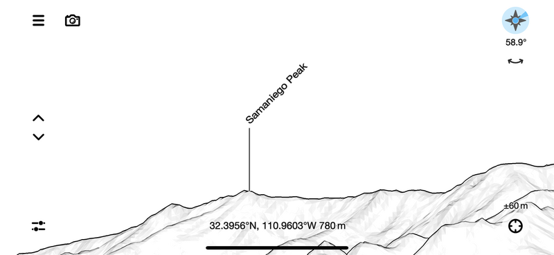
It may not directly help with your photography, but when posting photos to the web or social media, I really like to know what I'm taking pictures of. Tap the name of a mountain peak, and you'll get more information about it. In AR mode, you can actually see the mountains through your camera and have names and other info superimposed on the live picture.
So, those are my favorites. Each can enhance your time outdoors for sure. I use all these apps on almost every photo trek. I think you will too.
You'll have your own favorites. So share thoughts in the comments.


Join the Fstoppers community for free
-
Post comments and join in the discussions
-
Browse the site ad-free
-
Share your work and get featured in the community
-
Compete in the photo contests for fun and prizes
20 Comments
Peak finder should add off road trails by foot or vehicle to get to the peaks.
Another great app is Sunsurveyor. I have the iOS version, and it is available for Android, too. It gives positions for the Sun and Moon at any time or position, including rise and set times. It also lists times for civil, nautical and astronomical twilight, times for golden hour, blue hour, etc. My favorite feature is its "3D compass" that uses the GPS and inertial functions of the iPhone to show the paths of the Sun and Moon through the sky for the date and position chosen. This is great for easily planning shots for a given location. It's $9.99 on the App Store. Sunsurveyor and PhotoPills are my goto apps for planning shots when positions of the Sun and Moon are important.
Weather PRO, there is also a Premium version available, works good for Germany
sorry wrong answer
+1 for Sun Surveyor here. I use it on Android and it works like a charm.
Excellent choices. I'm looking forward to checking out Photo Pills. TPE is great, but I didn't know it shows the position of the Milky Way. How do you do that?
Hi Brian. Thanks for writing. For Milky Way tracking and visibility you need TPE 3D, not the regular version. Set the time, look toward the proper version of the sky, and you will see it. This time of year look SW.
mel
Here's my favorite apps. Never leave home without these!
Guys from Central & Eastern Europe! What weather apps do you recommend which actually works?! I have tested dozens of them, and from a photographer point of view - all of them are rubbish. I need nice meteograms with cloud cover on any level, available easily for a given location on a mobile device for the next (at least) few hours. Do you know any such thing? I've tried: yr.no, meteoblue, clearoutside, weatherundeground, windy and few local ones (like meteo.pl for PL) and all of them miss terribly with the cloud coverage and their level. I'm desperate for a really good weather app!
Clearoutside is my favorite. It is the most exact so far. I will keep it on my device. Otherwise I use (for Europe) the website (unfortunately no app) kachelmannwetter.de. You can choose different weather models and satellite images. Very exact and a multitude of parameters like due point, mist, mist with frost, 3 cloud levels, thunderstrikes and -storms, air and ground temperature, visibility range etc. Try that out.
I will - thanks! :)
EDIT: Actually this look pretty awesome - and they DO have a full variety of different weather apps. I know what I'm doing this weekend. 😎 Thanks a ton, Jens Sieckmann !
Gosh, I never saw that link in the footer "Apps for iOS and Android" ;-)
Most of them are paid with 30 days trials, but if they're as accurate as they say, it will be worth it. ;) (PS. different apps have different prices).
So far, I am happy with the website kachelmannwetter.de. I can save up to 5 locations and have most of the data I need.
Weather PRO, there is also a Premium version available, I use it in Germany.
Thanks for sharing Clear Outside. I've been looking for a weather app that shows cloud cover hourly, and this one looks excellent.
with all due respect, "Golden Time" and "Magic Hour" are not exactly the same thing as wrongly stated in this article here although one follows the other in and around TWILIGHT time, twice a day ...
early morning, just after the sky lights up and right before sunrise (Dawn) it's the Magic Hour that comes first (and disappears rather too quickly too!) and then after sunrise with sun's 'Golden Rays' lighting up everything we have the Golden Time, which lasts barely for more than a couple of hours in most places on the planet almost all year long ...
it's the reverse case later in the afternoon though, say after 3pm in most seasons almost everywhere in the world, when the "Golden Time" starts first (sunrays get more yellowish / orangish) and then as the sun goes down and closer to the horizon (actually when it completely vanishes from view!) then the "Magic Hour" or the real 'Twilight Time' starts near the evening time (Dusk) ...
there are more subtle changes in light in between the Golden Time and the Magic Hour until when it gets 'totally' dark btw ... the 'diagram' here may explain it in more detail ...
Hi Shawk. You are right, of course. There are finer deliniations as the sun rises or sets. However, most of the apps I've seen and used lump those finer gradations together, so I've adopted those conventions to keep it simpler. Thanks again for your comment. Mel
For Android, don't forget about Sun Locator. There's the Augmented Reality view and also the animated sundial on top of Google Maps that helps in estimating the shadows. And it's got all the magic hour (blue and golden hour) stuff, too.
Hey been looking at this, I can't find the button to get the 3d version or a street view, does this have it?