
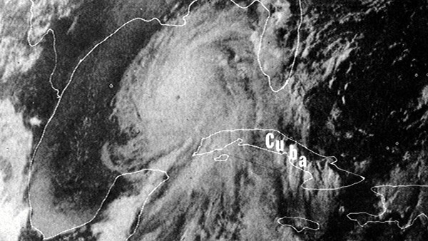
When Hurricane Camille filled the Gulf of Mexico in August 1969, satellites watched it the entire way in. The storm came ashore on the Mississippi coast as a Category 5 with sustained winds of 175 mph and a storm surge of more than 24 feet, and it killed more than 250 people. It would have killed many more if forecasters had not seen it coming from space. The Weather Bureau later estimated that the warnings and evacuations enabled by modern tracking and forecasting may have saved as many as 50,000 lives.
The images of Camille that survive from that week, the white spiral sitting over the warm water, look like photographs. It is natural to assume they were made the way photographs were made in 1969: light hitting film, film pulled from a camera, film developed in a darkroom. Somewhere up there, the thinking goes, a satellite carried a roll of film, and somehow that film came home and got soaked in chemistry and turned into the pictures we know.
That is not what happened. The satellites watching Camille had no film aboard at all. The real history of how the first satellites photographed the Earth is stranger than the assumption, and it splits into two stories that were unfolding at the same moment, in opposite directions, one of them in plain sight and one of them classified for thirty years.
The Weather Satellites Were Television Cameras
The machine that gave the United States its first weather pictures from orbit was a television satellite. TIROS-1, launched on April 1, 1960, was a 270 lb drum carrying two small TV cameras, and on its first day it sent back grainy views of clouds over New England and eastern Canada. There was no film involved. The camera was built around a vidicon, a type of television tube, and the vidicon does not record an image so much as measure one.
Here is how it worked. The lens focused the scene onto a small photoconductive plate inside the tube. Where the plate was struck by bright parts of the scene, its electrical properties changed. An electron beam then swept across that plate line by line, reading off the pattern of brightness as a varying electrical signal. The satellite could transmit that signal directly when it was within range of a ground station, or store the images on tape for later playback. The "photograph" never existed as a physical object in space. It existed as a scan, then as a radio signal, then as data waiting to be turned back into a picture on the ground.
By the time Camille arrived, the technology had matured but the principle had not changed. The operational weather coverage came from the ESSA satellites, run by the Environmental Science Services Administration, the agency that would later become part of NOAA. ESSA-9, launched in February 1969, carried RCA's Advanced Vidicon Camera System: two redundant 800-line television cameras that, from an altitude of roughly 1,450 km, produced images about 3,000 km across, with resolution of a few kilometers. It was still a television satellite. It still sent its pictures home as signals, not as film.
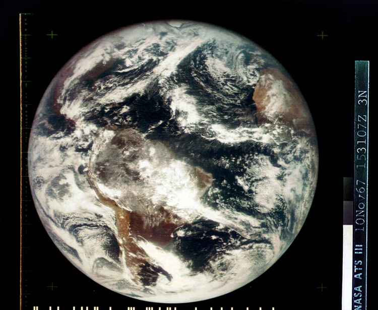
The most striking images of Camille, the ones showing the whole storm at once against the curve of the planet, came from a different and newer kind of satellite. ATS-3, launched in 1967, occupied geostationary orbit, circling the Earth once a day so that it matched the planet's rotation and remained over the same point on the equator. It carried a spin-scan cloud camera designed by Verner Suomi, the University of Wisconsin scientist often called the father of satellite meteorology.
The satellite spun, and on each rotation the camera captured a thin strip of the Earth, building a full disk of the planet line by line as the spacecraft turned. ATS-3 produced some of the first color views of the entire Earth, scanning a full disk in roughly 20 to 24 minutes with a practical cadence of about half an hour, which for the first time let forecasters watch weather move rather than infer it from snapshots. Suomi summarized the breakthrough of geostationary imaging in a single sentence: the clouds move, not the satellite.
So Where Did the Pictures Come From?
If nothing was developed in orbit, the image still had to be reconstructed somewhere, and that happened on the ground. When a weather satellite transmitted its scan, a receiving station fed the incoming signal into a facsimile recorder, a device closely related to the fax machine. As the signal varied, the recorder swept a stylus or a light source across the recording medium, brightening and darkening it line by line to rebuild the image the vidicon had measured. Sometimes that medium was photographic film or paper, exposed and developed in a lab; sometimes it was another form of hard copy. Either way, the picture a meteorologist eventually held in 1969 was built on the ground from a radio transmission. The light from the actual clouds never touched it.
There was an even more hands-on step hiding behind the famous global cloud maps of the era. A single satellite pass only saw a strip of the planet, so to build a picture of the entire world's weather, technicians assembled mosaics by hand, trimming and fitting hundreds of individual frames into one composite. The first photomosaic of the entire planet's cloud cover, made from TIROS-9 imagery, was stitched together from 450 separate photos taken on a single day in February 1965. The meteorologist Tetsuya Fujita, later famous for the tornado scale that bears his name, did some of his pioneering work in this period by tracking cloud motion frame by frame through these satellite images by hand. The automation we take for granted, where a computer assembles a seamless global view, came later. In the 1960s, the seams were closed by people with steady hands.
Meanwhile, Film Really Was Falling Out of the Sky
Here is the twist. At the very moment the weather satellites were turning the Earth into radio signals, another set of American satellites was doing the thing everyone assumes the weather satellites did. They carried real photographic film, exposed it in orbit, and then dropped it back to Earth. The catch is that this program was one of the most closely guarded secrets of the Cold War, and the public did not receive official confirmation of the truth until it was declassified in 1995.
The program was called CORONA, and for years it hid behind a cover story. Approved by President Eisenhower in 1958, it was publicly described as a space-science effort named Discoverer, supposedly studying conditions in orbit and testing recovery techniques. The real mission was to photograph the Soviet Union from space at a time when there was no way to send an image home electronically at the resolution intelligence analysts needed. If you wanted a sharp picture from orbit, you had to use film, and if you used film, you had to physically get it back.
The CORONA satellites carried panoramic cameras, designated by the code name Keyhole, that exposed long rolls of film as the spacecraft passed over its targets. The exposed film was reeled onto spools inside a reentry capsule that crews nicknamed the "bucket." When a roll was finished, the bucket separated from the satellite, fired a small retrorocket to drop out of orbit, and fell toward the Pacific. A heat shield protected it through the fire of reentry and was jettisoned around 60,000 feet. Then a parachute opened, and a propeller-driven Air Force cargo plane, a C-119 Flying Boxcar trailing a hook, flew into the descending capsule's path and snatched the parachute out of the air, reeling the bucket aboard in mid-flight.
The system had a backup for when the catch failed, which it often did in the early years. The bucket was designed to float if it hit the ocean, giving Navy ships about two days to reach it. After that, a salt plug built into the hull would dissolve and the capsule would scuttle itself, sinking the film to the bottom rather than letting it fall into the wrong hands.
The first capsule ever recovered from space, Discoverer 13 in August 1960, carried no camera; it was a test flight, and it earned its place in history simply by being the first man-made object brought back from orbit. The film came days later. On a launch days afterward, the satellite that the public knew as Discoverer 14 carried a Keyhole camera and about 20 lb of film, and on August 19, 1960, a C-119 snagged its parachute at 8,000 feet roughly 360 miles southwest of Honolulu. That single flight returned images covering more than 1,650,000 square miles of Soviet territory, more than every previous U-2 spy-plane mission combined. Only then, with the film on the ground and unspooled in a laboratory, was it finally developed into pictures.
The cameras improved relentlessly. The earliest CORONA images could resolve objects on the ground about 35 to 40 feet across. Later generations brought that down to roughly 5 to 7 feet, an astonishing leap for the era. Across 145 missions, more than 100 of them successful or yielding usable imagery between August 1960 and the last recovery in May 1972, the program returned an archive of film that let the United States count Soviet missiles and bombers with enough confidence to support the first strategic arms-control agreements, signed in 1972. The buckets did not always land where they were supposed to. In one famous case in 1964, a capsule came down off course and was found by farmers in Venezuela.
Two Ways to Photograph a Planet
What makes this history worth telling is that the two approaches were happening simultaneously and represent opposite answers to the same problem. The weather satellites solved it electronically. They refused to carry film at all, converting the image into a measurement and then a signal, accepting lower resolution in exchange for the ability to send a picture home in minutes, over and over, as often as the weather changed. The spy satellites solved it photographically. They kept faith with film and its unmatched detail, and then took on the staggering engineering challenge of physically returning that film through the atmosphere and catching it with an airplane, accepting that each precious roll could be used only once and recovered only at great risk.
Both were photography in the broadest sense, and neither matched the simple picture most people carry of how it must have worked. The storm that bore down on the Mississippi coast in 1969 was watched by television tubes that never held a frame of film, while in the same skies, buckets of exposed film were falling toward the sea to be plucked up by cargo planes. The image of Camille that helped save tens of thousands of lives was, in the end, a radio transmission redrawn onto paper by a machine on the ground. It only looks like a photograph. The truth of how it was made is far more interesting.


Join the Fstoppers community for free
-
Post comments and join in the discussions
-
Browse the site ad-free
-
Share your work and get featured in the community
-
Compete in the photo contests for fun and prizes
2 Comments
A very interesting history. Thank you. Stepping out of the mindset of a photographer, I don't think the CORONA program was so much about keeping "faith with film" than about the different needs of meteorology versus intelligence at the height of the Cold War. The meteorological community could settle for low-resolution images of weather systems, but those systems covered hundreds of miles and changed by the hour, so electronic transmission was the best choice. The intelligence community needed high resolution images of installations that didn't change often, since it took months to build an air base or missile silo, so film was the preferred solution.
That's super insightful. Thank you, Michael! And thank you for the kind words!